Here is the official morning report on the fires in the Thompson-Divide Complex, including the Thompson, Sheep, Granite and Spruce blazes. The items of immediate interest are the the reopening of U.S. Highway 2 between West Glacier and East Glacier and the resumption of rail traffic through that corridor . . .
Fire Information: (406) 387-4854/ (406) 314-1669, 8 a.m.-8 p.m.
Resources – Total Personnel: 268 Injuries: 1 Structures Lost: None
Hand Crews: 5 20-person, 1 Wildland Fire Management Modules, 1 Helitack Crew (10), Smokejumpers (3)
Air Support: Helicopters (2 Type-1 & 2 Type-3), Engines: 13
The Thompson-Divide Complex is comprised of the Sheep, Granite and Spruce Fires on the Flathead National Forest and the Thompson Fire in Glacier National Park.
Highway 2 is reopened, with pilot cars escorting traffic in both directions to ensure safe traffic flow through the fire area. Pilot cars will run 24 hours a day, but the highway could be closed due to changing fire conditions. Expect delays of 10-15 minutes. Call 511 or visit http://www.mdt.mt.gov/travinfo/alerts.shtml for current road status.
There will be a public meeting at the Izaak Walton Inn tonight, Sunday, August 23rd at 8:00 pm.
The BNSF and Amtrak trains have been running. For more information on Amtrak call 1-(800) 872-7245.
Stage II Fire Restrictions are in effect for Northwest Montana.
‘Set’ stage alert is still in effect for residents and businesses in the vicinity of Essex for possible evacuation.
Today weather conditions will continue with a warming and drying trend that will bring higher temperatures of 75 to 80 degrees in the valleys. A mild inversion is expected to break early afternoon. Fire activity is expected to increase to moderate, with more ventilation.
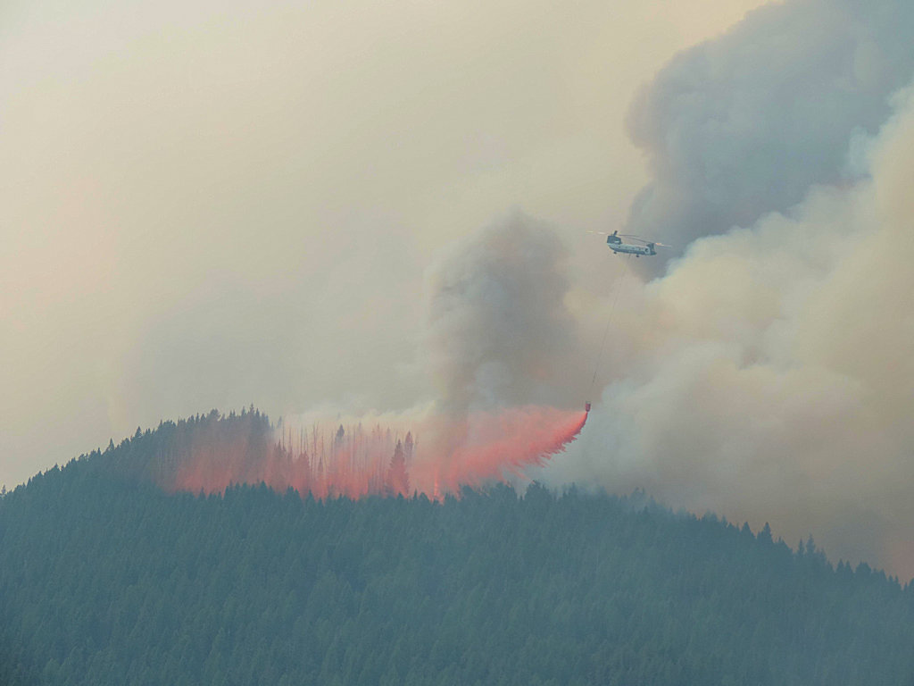
Air operations will continue today with two Type 1 helicopters, a Sky Crane and Chinook. A mobile fire retardant base is being used for helicopter bucket drops.
Visit http://svc.mt.gov/deq/todaysair/ for air quality info. Closures are in effect for some trails in the vicinity of the fires for Glacier National Park and Flathead National Forest. For more info, please see Glacier NP page http://www.nps.gov/glac/index.htm or for Flathead NF call Hungry Horse Ranger District (406) 387-3800.
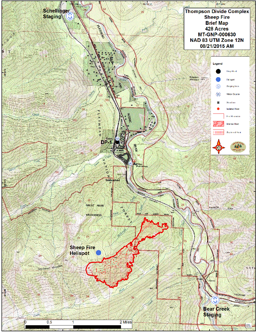
Sheep Fire, Flathead National Forest Link to http://inciweb.nwcg.gov/incident/4468/
Structures At Risk: 200+ structures, BNSF has several wooden snowsheds and 1 wooden trestle, utilities infrastructure
Approximate Size: 581 acres Containment: 0% Structures Lost: None
Fire Update: The Sheep Fire is about 1 mile south of Essex in the Great Bear Wilderness of Flathead National Forest. It is burning in very steep, difficult terrain with limited access. Increased fire activity is expected today with warmer, drier conditions. Three crews may start building fire line today if conditions permit on the NE flank of the fire on the steep face across from the Goat Lick and to the north. Helicopters will support line building efforts as needed. Goals are to keep this fire from going north towards Essex and moving into the transportation corridor along the Middle Fork of the Flathead River.
Residents in the Highway 2 corridor around Essex remain in the ‘Set’ Stage of the Ready, Set, Go evacuation strategy. Residents of Essex and the surrounding area have been advised that they may be evacuated if the Sheep Fire becomes an imminent threat. People should have critical property and needs loaded into their vehicles in preparation for evacuation. They should have an evacuation plan in place and make sure everyone knows the plan. Visit http://www.wildlandfirersg.org/ for more information. The night shift continues to monitor fire movement.
Granite Fire, Flathead National Forest Link to http://inciweb.nwcg.gov/incident/4468/
Approximate Size: 176 acres Containment: 0%
Fire Update: The Granite Fire is west of Marias Pass and south of Hwy. 2 in the Great Bear Wilderness. It is burning in very steep terrain in a mixed conifer forest below a ridge. Crews have implemented structural protection measures on several backcountry cabins, trailhead structures, a wooden road bridge, and a radio repeater. Three engines will be on this fire today. The Granite Creek Trail (#156) is closed. Yesterday the fire was most active to the north and west.
Spruce Fire, Flathead National Forest Link to http://inciweb.nwcg.gov/incideuppression actionsnt/4468/
Approximate Size: 3 acres Containment: 100% Fire Update: The Spruce Fire was added to the complex Aug. 19. The Spruce Fire is about 5 miles south of U.S. 2 at Bear Creek in the Great Bear Wilderness. Crews worked on establishing control lines yesterday and this small fire is now at 100% containment. Today crews will finish up monitoring and checking for any remaining hot spots. The fire will go into monitoring status.
Thompson Fire, Glacier National Park Link to http://inciweb.nwcg.gov/incident/4468/
Approximate Size: 14,095 acres Containment: 0%
Structures At Risk: 2 historic cabins Structures Lost: None
Fire Update: The Thompson Fire is located in a remote south-central backcountry area of Glacier National Park about 15 miles east of the West Glacier entrance in the Thompson and Nyack drainage and west of the Continental Divide.
Crews achieved some containment yesterday and are close to finishing mop-up of all edges of the fire. The fire remains west of the Divide and poses no threat to communities around East Glacier and St. Mary. Crews are shifting focus to rehabbing their camp and leaving this fire. The fire will go into monitoring status.
Most of Glacier National Park is unaffected by this wildfire complex and is available for recreational use. Limited backcountry closures are in place. For more specific visitor information, please see the website http://www.nps.gov/glac/index.htm.
The Thompson Fire has not impacted any park roads. The Going-to-the-Sun Road is open.
For information on the Reynolds Creek fire, please visit http://inciweb.nwcg.gov/incident/4405/#