Tag Archives: wildfire information

Glacier Park’s Thompson Fire now 1900 acres

Thompson Fire from Scalplock Mountain Lookout, August 10, 2015 - courtesy of Bill Fordyce
Thompson Fire from Scalplock Mountain Lookout, August 10, 2015 – courtesy of Bill Fordyce

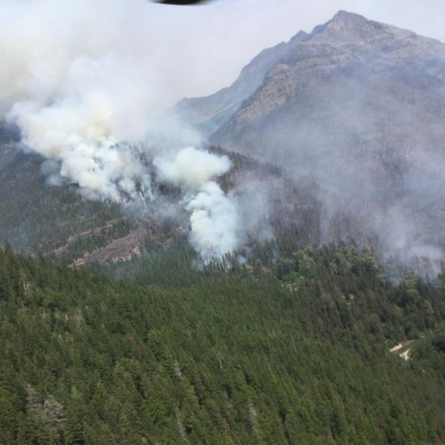
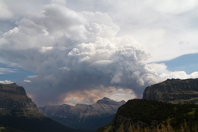
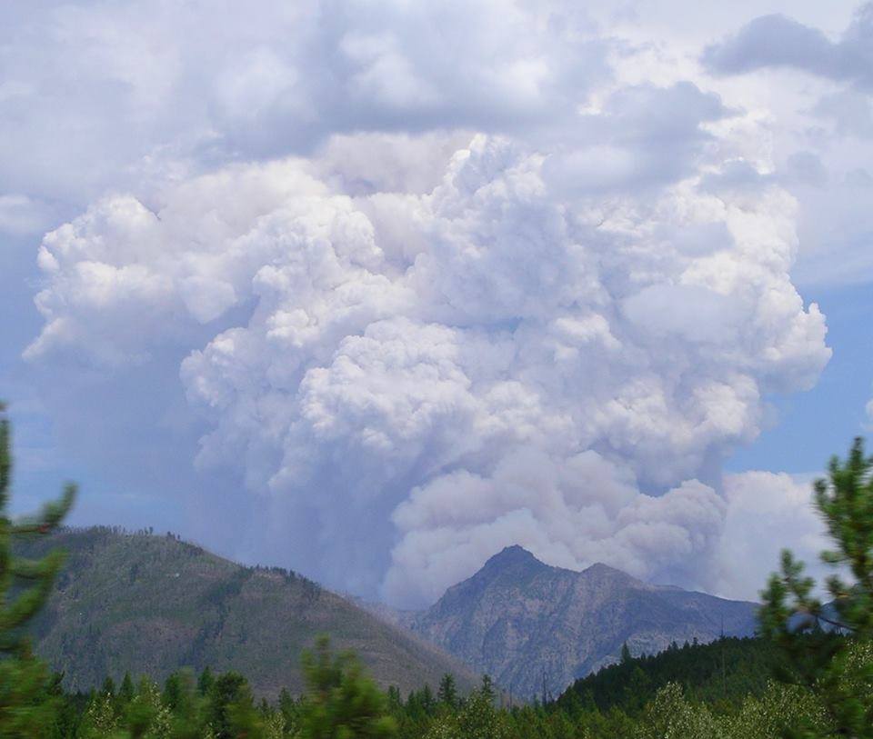
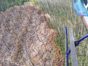
Here’s the latest InciWeb information on the Thompson Fire. It is now 1900 acres in extent; it was around 150-200 acres this morning . . .

Incident Overview

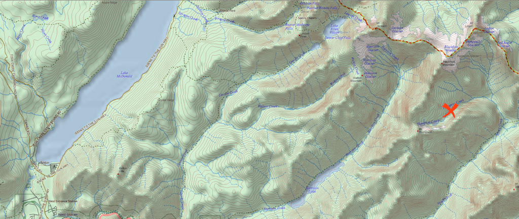
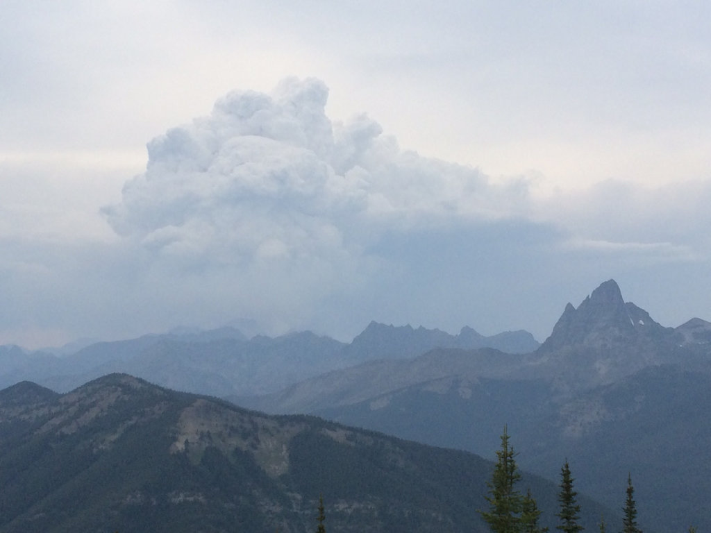
The Thompson Fire was reported at approximately 1:30pm on Sunday August 9. It is burning in rugged terrain in the remote Nyack area of the park.

As of Monday evening, the fire is estimated to be 1,900 acres.

Aerial resources are being used on the Thompson Fire to attempt to control fire spread. Due to the remote, rugged terrain, ground resources are not being used at this time.

The majority of Glacier National park is unaffected by this wildfire. For more specific visitor information , please see official websites (http://www.nps.gov/glac, twitter.com/glaciernps, and flickr.com/photos/glaciernps). Additionally you can view park webcams at http://www.nps.gov/glac/learn/photosmultimedia/webcams.htm.

Basic Information

Current as of 8/10/2015, 6:59:42 PM
Incident Type Wildfire
Cause Under Investigation
Date of Origin Sunday August 09th, 2015 approx. 01:30 PM
Incident Commander Justin Kebar’s Type 3 Incident Management Team

Current Situation

Size 1,900 Acres
Fuels Involved Heavy Timber


Aerial View of Thompson Fire, August 10, 2015

Firefighters responding to Thompson Fire

Smoke Plume from the Thompson Fire as seen from Logan Pass - NPS PHOTO-Andrew Englehorn
Smoke Plume from the Thompson Fire as seen from Logan Pass – NPS PHOTO-Andrew Englehorn

From the official press release . . .

A new wildland fire was reported on Sunday, August 9 around 1:30pm. The fire was reported from Glacier National Park’s Loneman Lookout. The Thompson fire, burning in the remote Nyack area of the park, is estimated to be 150-200 acres in size. The Upper Nyack Cabin is threatened by the fire.

A smoke plume from the Thompson Fire was visible from areas east of the continental divide yesterday.

Aerial resources are being used on the Thompson Fire to attempt to control fire spread. Due to the remote, rugged terrain, ground resources are not being used at this time to support aerial firefighting efforts.

The Thompson Fire has prompted closure of the Nyack and Coal Creek area, including trails and backcountry campsites and the section of trail from Nyack Creek to Cutbank Pass. For updated information on trail status, visit http://www.nps.gov/glac/planyourvisit/trailstatusreports.htm

A Type III Interagency Incident Command Team is working with Glacier National Park to respond to the fire, with personnel from the Flathead National Forest, the Montana Department of Natural Resources and Conservation, and National Park Service resources.

Also read . . .

Fire burns in heavy timber in remote part of Glacier (Daily Inter Lake)

New Fire in Remote Part of Glacier National Park Closes Backcountry Sites (Flathead Beacon)

Glacier Park’s Thompson Fire continues to grow

Smoke plume from Thompson Fire August 9, 2015 - Rachel Jenkins photo
Smoke plume from Thompson Fire August 9, 2015 – Rachel Jenkins photo

Chris Peterson of the Hungry Horse News gets the prize for best coverage of the Thompson Fire this morning . . .

A wildfire fire in the southern backcountry of Glacier National Park put up an impressive plume Sunday, forcing the closure of several backcountry campgrounds in the potential path of the blaze.

The Thompson Creek Fire was roughly 500 acres and is burning west of the Upper Nyack Creek campground. Thompson Creek is about 14 miles north of U.S. Highway 2 one of the most remote areas of Glacier. The fire currently does not threaten any roads, but at least two hikers were airlifted safely from the blaze.

But fire has the potential at burn into the Cut Bank Pass area. Temperatures are expected to be in the 90s for the next few days with gusty winds as thunderstorms roll through.

Read more . . .

Also note that there is now an InciWeb entry for the Thompson Fire at http://inciweb.nwcg.gov/incident/4468/

Resources being marshaled to fight Thompson Fire in Glacier Park

Smoke plume from Thompson Fire August 9, 2015 - Rachel Jenkins photo
Smoke plume from Thompson Fire looking up Harrison Creek, August 9, 2015 – Rachel Jenkins photo

An evening update on Glacier Park’s Thompson Fire . . .

A wildfire reported in the Thompson Creek drainage area in Glacier National Park had grown to an estimated 200 acres by 8 p.m. Sunday.

The fire is located about a mile southeast of Mount Thompson and about eight miles north up Nyack Creek from U.S. 2. A Type 3 team was ordered for the fire.

Ema Braunberger, public affairs officer for the Flathead National Forest, said a helicopter was on the scene and other heavy helicopters were en route.

Read more . . .

Thompson Fire burning in Glacier Park; type 3 team called in

Approximate location of Thompson Fire

A new blaze, the Thompson Fire, was reported in Glacier Park a little before 2:00 pm this afternoon. According to the Kalispell Interagency Dispatch Center entry, it is around 200 acres (estimates vary wildly) and two helicopters are already working on-site. A type 3 team has been called in.

The fire is located in Glacier Park’s Thompson Creek drainage, below Mount Thompson and about 12 miles east of Lake McDonald. Thompson Creek is a tributary of Nyack Creek.

‘Wildfire Information’ page updated

The “Wildfire Information” page has a couple of minor updates.

First off, the phone numbers for reporting wildfires are now prominently displayed.

Also, the description of the Kalispell Interagency Dispatch Center has been updated to include information on accessing the incident logs — very handy when you want to know why there are trucks and helicopters running around the neighborhood.

Crews hold line on Glacier Rim fire, increase containment

Fire crews appear to have a good handle on the Glacier Rim fire. Containment reached 70% yesterday and the recent rain helped a bit. Fire extent stayed at 100 acres. Here is the most recent report from the InciWeb site . . .

Yesterday, July 6, Fire crews maintained fire lines around the slop-over from July 4th. Firefighters are falling hazardous snags to remove fuel near the fire line. All three helicopters provided water and visual support for the fire. An additional water tender was ordered and assisted in cooling the south flank of the fire to enable crews to begin mop up process. The Flathead County structure protection team continued to contact residents and assess structures Spoon and Bailey Lake residential area.

Northern side of the Glacier Rim fire from helicopter

Current Situation:

Rd 316, Canyon Creek Road, has been closed at the junction with the North Fork Road #486 and at the junction at Trumbull Creek Road #9848 to public access.

The fire received a small amount of rain overnight and more is expected through the morning. Crews laid hose around the fire and will be cooling down the perimeter and hot spots with support from the water tenders. Hazard snag removal will continue along the south flank of the fire. Firefighters continue to reinforce and hold already established containment lines around the perimeter of the fire.

FOR YOUR AND THE FIREFIGHTERS’ SAFETY, DO NOT STOP IF YOU ARE TRAVELING IN THE FIRE AREA. Vehicles driving on the North Fork Road are asked to not stop in the fire area. River floaters on the river are asked to not stop in the fire area

Glacier Rim fire at 100 acres, 70 percent contained

Although mostly contained, the Glacier Rim fire continues to smolder in downed timber from the 2003 Robert Fire . . .

Stoked by high winds the night of July 4, the Glacier Rim Fire slopped over containment lines on its south and southwest flank, growing another 15 acres.

The fire is now at 100 acres. Cooler temperatures July 5 helped firefighters get a line around the slop area and the fire is now listed at 70 percent contained.

Forest Service Road No. 316 — the Canyon Creek Road, is closed to vehicles as firefighters are using it to reach the south end of the fire.

Read more . . .

More reading:

Idaho fire destroys homes while containment grows at Glacier Rim (Missoulian)

InciWeb page for Glacier Rim fire (USFS)

High winds cause 25-acre spot fire near Glacier Rim blaze

Well, rats. High winds triggered a hefty spot fire along the southern/southwest boundary of the Glacier Rim Fire . . .

Firefighters are trying to contain a 25-acre spot fire that was caused by high winds near the Glacier Rim Fire up the North Fork. According to the U.S. Forest Service, additional resources have been ordered to help contain the slop-over near the containment lines in the south and southwest corners.

Firefighters continue to reinforce and hold already established containment lines around the perimeter of the original fire, which has burned 85 acres and is 70 percent contained. The human-caused fire, situated north of Columbia Falls off the North Fork Road, started June 27. An investigation into the cause of the incident is underway.

Canyon Creek Road has been closed to public access at the junction with the North Fork Road #486 and at the junction at Trumbull Creek Road #9848.

Read more . . .

Glacier Rim Fire winding down

Looks like the Glacier Rim Fire is winding down . . .

Crews continue to mop up the Glacier Rim Fire west of Glacier National Park. The fire is listed at 82 acres and is burning in the old Robert Fire burn of 2003 in downed timber and brush.

The fire has seen no growth in the past several days and spot fires in Glacier National Park have been put out as well. The fire continues to burn inside the perimeter, however and is listed at 50 percent contained. Because of snag danger, the interior fire is being allowed to burn, with helicopter drops on hot spots to stop any spreading.

Read more . . .