The Kootenai National Forest is scrambling to deal with a number of new wildfires . . .
The Kootenai National Forest added 14 new fires Saturday to its growing list that totals 49 wildfires that have started since Aug. 1.
Lightning raked the forest Friday night, igniting new fire starts.
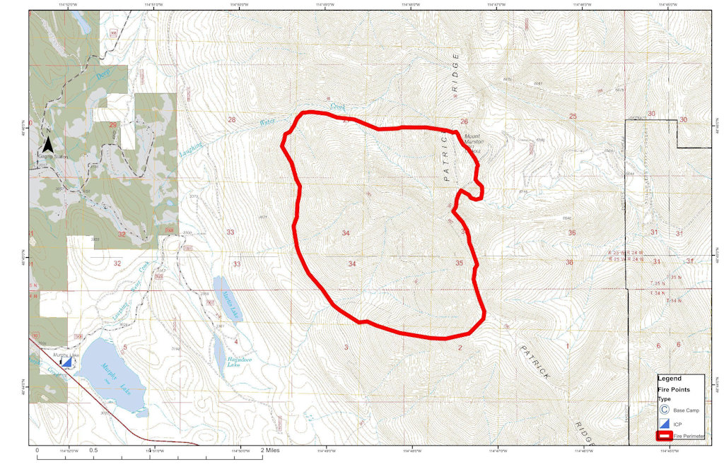
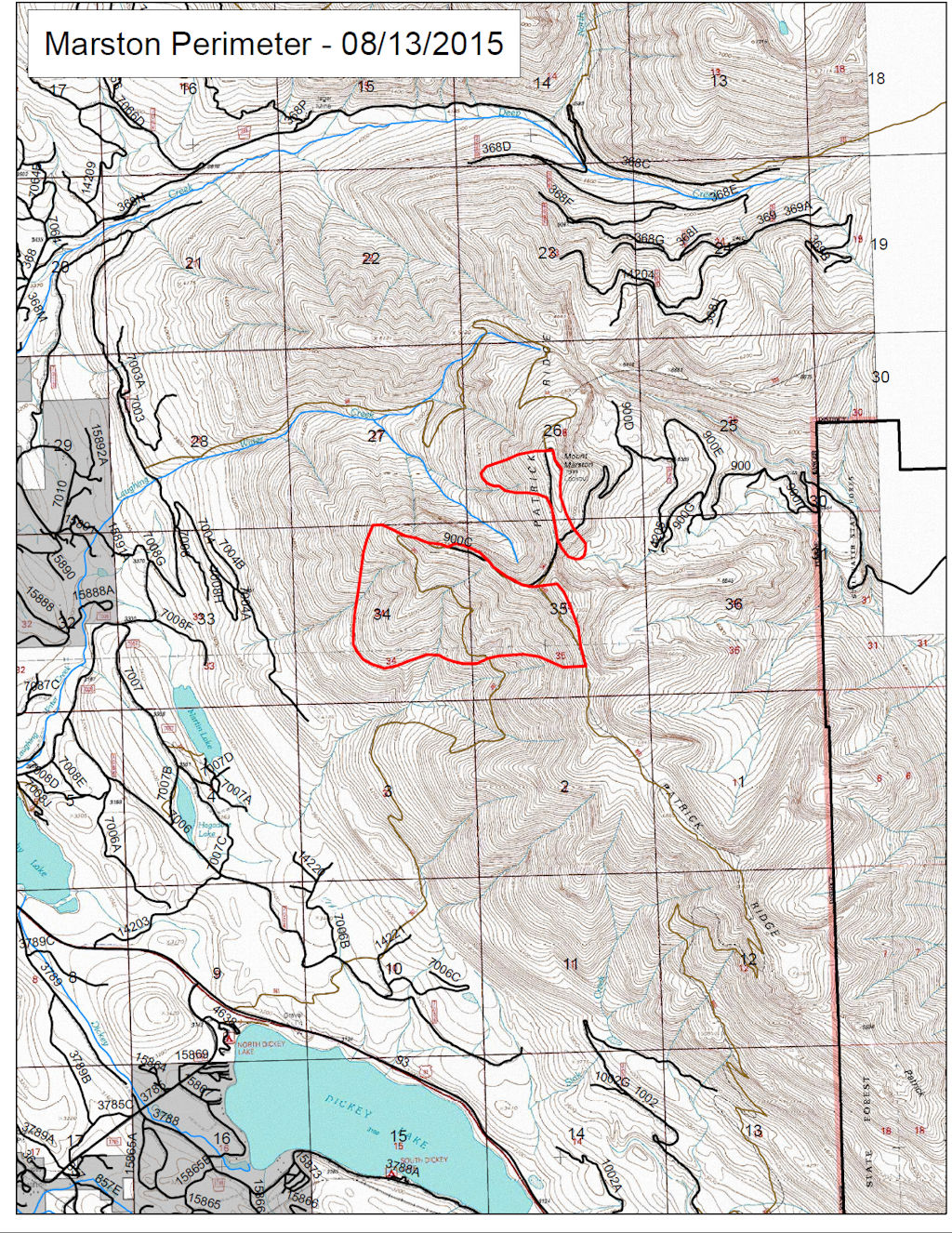
The largest fire — the Marston Fire near Trego — had grown to 1,500 to 1,800 acres as of Saturday afternoon, according to Kootenai National Forest Public Information Officer Willie Sykes.
Here’s the noon update on the Marston Fire. Short version: The blaze is up to about 1500 acres. Shawn Pearson’s Type II team will be taking over tomorrow (Sunday) morning, which means they are taking this fire pretty seriously.
FIRE UPDATE
Marston Fire
Fortine Ranger District, Kootenai National Forest
August 15, 2015, 12:00 p.m.
Fire Information Line: (406) 882-8308 starting August 15
Office Hours: 8:00 a.m. to 8:00 p.m.
What: Wildland Fire Detected: August 11, 2015 Cause: Lightning Current Size: Estimated 1,500 Acres Containment: 0% Resources on Fire: 3 feller bunchers, 2 skidders, 1 dozer, 2 dozer bosses, 1 dozer boss trainee, 15 district fire personnel Location: Approx. 15 miles SE of Eureka, MT on the Fortine District of the Kootenai National Forest.
Status: Due to steep terrain, extremely dry fuels, high temperatures and low humidities, the fire grew significantly yesterday. Firefighters worked on establishing a contingency line in the Laughing Water/Summit Creek area with feller bunchers and dozers. Local district personnel responded to several lightning strikes/new fire starts with initial attack. A trace of rain fell on the fire overnight.
Today the weather is expected to be overcast with cooler temperatures (60-70° degrees) and a higher relative humidity. These conditions should moderate fire behavior. Firefighters are working on building a fuel break on the East side Deep Creek.
Shawn Pearson’s Northern Rockies Type 2 Incident Management Team is onsite at the Fortine Ranger District and will be transitioning with the district personnel. The team is expected to take command of the fire on Sunday, August 16.
Special Messages/Closures: The top priority is firefighter and public safety. Closures in the Marston face area, Stillwater area, and Laughing Water area remain in effect. An expanded area closure went into effect early this morning and is posted on inciweb.There are no evacuations in effect at this time.
There will be a community meeting at the Trego Community Hall at 7:00 pm on Sunday evening, August 16.
The Marston Fire ballooned up to 1200 acres. A Type II team is due on site tomorrow (Sunday) morning . . .
As many as 26 new fires had been reported in the Kootenai National Forest area by Friday evening, with a previously reported pair of fires on Mount Marston erupting to cover 1,200 acres.
The two fires were being managed as a single incident dubbed the Marston Fire and are burning about two miles northeast of Dickey Lake and four miles northeast of Trego.
The fires are threatening the Mount Marston Lookout.
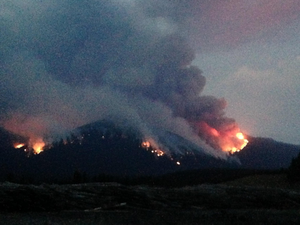
UPDATEDto include newer information, including several corrections from Jon Cohan, who can see the Marston Fire from his back deck. Here’s what he has to say: “The Mt. Marston fire started overnight on Mon. during a lightning storm and was spotted early on Tues. morning by a local USFS crew who were in action as early as 8:00 am. The fire initially started on the southwest slope facing Rte. 93 and grew as it traveled uphill during the day. It has grown considerable larger since then, overtaking the peak and spreading to nearby terrain via ember deposits.”
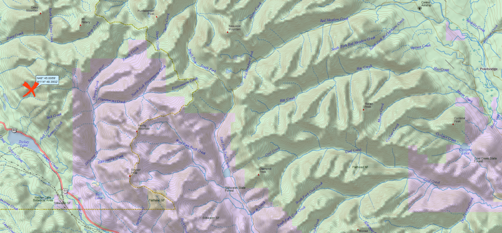
The smoke plume from the Marston Fire is visible from the North Fork. It is burning on Mt. Marston in the Kootenai National Forest, a little over 4 air miles east of Fortine and about 21 miles west of Polebridge.
According to the InciWeb page, fire crew access is limited due to steep terrain. The Mt. Marston Lookout is threatened by the blaze and has been bundled up in fire retardant wrap. The most recent report puts the fire’s size at 550 acres.