Tag Archives: Marston Fire

Northeast Kootenai Complex – Marston Fire Update – September 8, 2015

Marston Fire photo by Stonehenge Air Museum, Aug 28, 2015


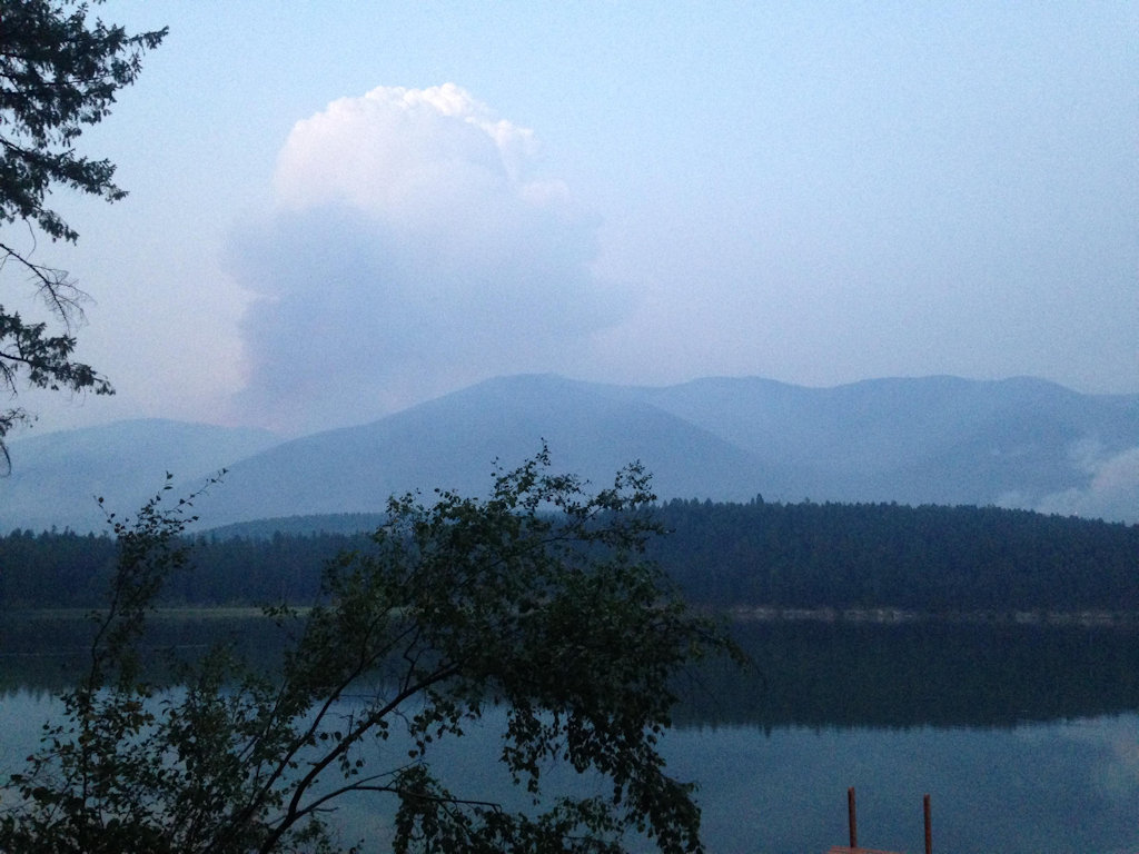
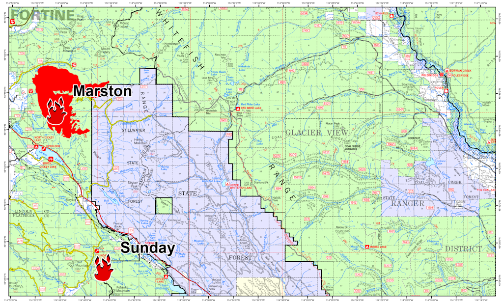
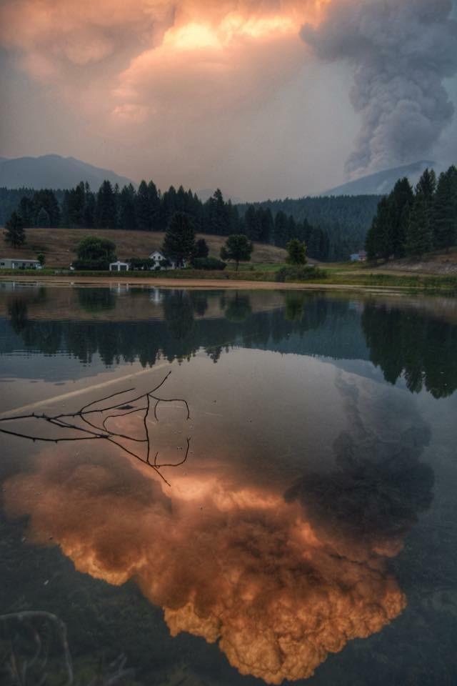
Here’s this morning’s update on the Marston Fire, the only remaining wildfire of note in the Northeast Kootenai Complex. Activity is winding down. The cool, wet weather has really had an impact on fire behavior . . .

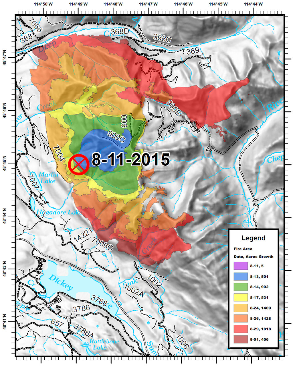
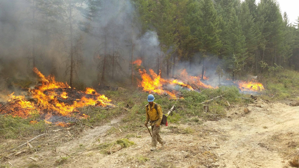
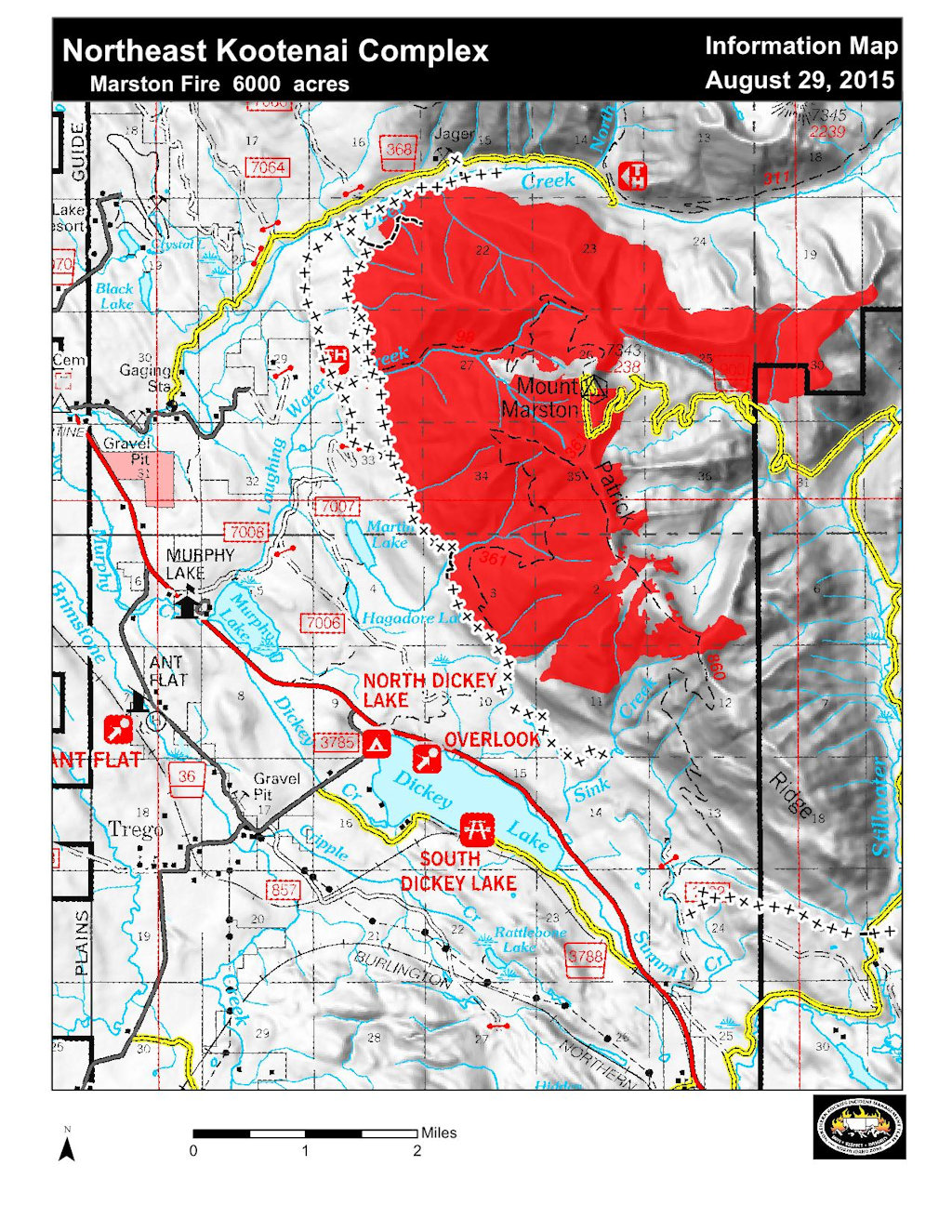
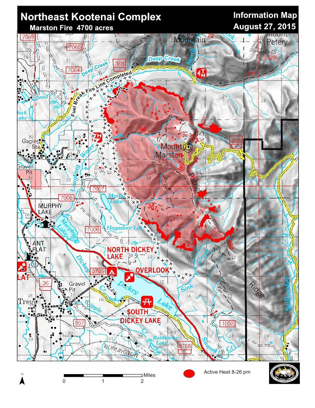
Murphy Lake, MT – The Northeast Kootenai Complex – The Marston Fire activity has decreased with the recent rains and increased relative humidity. The fire continues to be monitored, although suppression repair is now being implemented. Handline constructed by firefighters is being repaired to improve erosion within the fire perimeter. The eastern side of the fire is extremely difficult due to terrain and poor access which drastically limits the ability to use direct fire suppression tactics because of the danger to firefighting resources. The large fuel moistures are still low. The fire behavior continues to be minimal, only smoldering has been observed. Incident Commander Gabe Holguin would like to thank the firefighters for their hard work and positive attitude. “These firefighters hit the ground ready take on whatever the Marston Fire handed them and they rose to the occasion,” stated IC Holguin, “handling steep terrain, and difficult access and a changing strategy in stride.”

The Marston Fire is being supported by, 1- Type 1 Crews, 2- Type 2 Crews and miscellaneous personnel for a total of 120 fire personnel and support on the fire.

The weather forecast calls for a chance of rain today and then some drying developing on Wednesday and continuing later into the week.

A new Fire Area Closure Order has replaced Marston Fire Area Closure Order # D03-067-S-15, reducing the area restricted for public use. The Closure Order in effect now allows public access Murphy Lake and Campground. All other lands, roads and trails previously closed, remain closed for public safety. Please see NE Kootenai Complex on InciWeb at: www.inciweb.nwcg.gov for a full list of trails and roads affected by this closure.

North Fork and Grave Creek/10 Lakes area closures lifted

In case it you missed it in this morning’s Kootenai fire complex report, the North Fork area closure in the Flathead Forest and the Grave Creek/10 Lakes area closure in the Kootenai Forest have been rescinded. The Forest Service is no longer worried about the Marston Fire making a run toward the North Fork. Also, Trail Creek Road is open again all the way through. Looks like the cool, damp weather is really helping.

Northeast Kootenai Complex morning update – Sep 3, 9:30 am

Here’s this morning’s report on the Northeast Kootenai Complex fires.

Well now, here’s some good news:The North Fork area closure in the Flathead Forest and the Grave Creek/10 Lakes area closure in the Kootenai Forest have been rescinded. The Forest Service is no longer worried about the Marston Fire making a run toward the North Fork. Also, Trail Creek Road is open again. Looks like the cool, damp weather is really helping.

Additionally, Gabe Holguin’s Type III Management team is taking over from Shawn Pearson’s Type II team this evening . . .


Information Officers: Katie Knotek, Tom Rhode & Meg Nemitz
Fire Information Line: (406) 882-8308
Office hours: 8:00 a.m. to 8:00 p.m.
Email: northeastkootenaicomplex@gmail.com

INCIDENT: Northeast Kootenai Complex (includes Barnaby, Marston, and Sunday Fires)
AGENCY JURISDICTION: USDA Forest Service, Kootenai & Flathead National Forests; Montana DNRC, Libby and Stillwater Units.
INCIDENT COMMANDER: Shawn Pearson, Northern Rockies Type II Incident Management Team (IMT). The Incident Command Post (ICP) is located at the Murphy Lake Ranger Station.

TEAM TRANSITION: The Northern Rockies Type II Incident Management Team lead by Shawn Pearson has reached the end of a maximum 21 day assignment. The Team will transfer command of the fire today to Gabe Holguin’s Type III Southwest Incident Management Team at approximately 6:00 p.m. This will be the last Fact Sheet distributed by Pearson’s Team. The incoming team will begin to disperse information about the Northeast Kootenai Complex Friday morning.

WEATHER & FIRE BEHAVIOR: The cooling trend with temperatures in the 50’s and higher relative humidity around 50% will keep fire activity moderate throughout the weekend. Mild winds will be predominantly out of the southwest, and rain is predicted as the weekend progresses.

MARSTON FIRE:
The Marston Fire is at 7,000 acres with 30% containment. Crews and machinery are working east of Jager Mine reinforcing line to keep the fire south of Deep Creek. Fireline from Deep Creek south to about one mile above Sink Creek continues to hold and is keeping the fire from moving west. On the south-southwest side of the fire, crews are mopping up previous days’ burnout operations and may continue burnout operations weather permitting. Helicopters are still available and will be used as necessary to aid firefighters with slowing the fire’s progression.

SUNDAY FIRE:
The Sunday Fire, southeast of Stryker, MT, is 100% contained at 60 acres and is in patrol status.

BARNABY FIRE:
The Barnaby Fire, located about four miles northeast of Eureka, is being monitored by air daily due to its location in steep rugged terrain. Helicopters are still available to drop water as needed.

PERSONNEL AND RESOURCES: 215 personnel including 2 Type -1 crews, 2 Type – 2 crews, 2 engines, 3 helicopters (2 Type – 1 Chinook, 1 Type – 2), 1 dozer, 2 water tenders, and 1 skidgine.

SPECIAL MESSAGES/CLOSURES:
• Barnaby Fire Area Closure (Grave Creek/10 Lakes Area, Kootenai National Forest) Order #D03-066-S-15 has been rescinded.
• Northeast Kootenai Complex Area Closure (North Fork Area Closure, Flathead National Forest) Order #D07-099-S-15 has been rescinded.
• Barnaby Fire Trail Closure (Sinclair Creek Trail #88) Order #D03-065-S-15 is STILL IN EFFECT.
• Marston Fire Area Closure Order #D03-067-S-15, Kootenai National Forest, is STILL IN EFFECT.

These closure orders can be viewed on InciWeb, please see link below.

For more information on the fires, visit: http://inciweb.nwcg.gov/; Select “Northeast Kootenai Complex.”

Marston FIre Progression, Sep 2, 2015

Northeast Kootenai Complex morning update – Sep 2, 8:00 am

Mushroom Cloud Over Marston Fire - Aug 25, 2015- Evening
Mushroom Cloud Over Marston Fire – Aug 25, 2015- Evening

Here’s this morning’s report on the Northeast Kootenai Complex fires.

Of greatest interest to North Forkers is the Marston Fire, which made a run to the northeast recently, resulting in a precautionary closure of a section of the Flathead National Forest in the North Fork. The cooler, wetter weather that moved into the area has made life easier for crews fighting this blaze. It is still not anywhere close to the North Fork and has not grown over the last few days.

Also see the Northeast Kootenai Complex Proximity to Flathead NF Map for information on the position of the Marston Fire in relation to major North Fork features.


Information Officers: Katie Knotek, Tom Rhode & Meg Nemitz
Fire Information Line: (406) 882-8308
Office hours: 8:00 a.m. to 8:00 p.m.
Email: northeastkootenaicomplex@gmail.com

INCIDENT: Northeast Kootenai Complex (includes Barnaby, Marston, and Sunday Fires)
AGENCY JURISDICTION: USDA Forest Service, Kootenai & Flathead National Forests; Montana DNRC, Libby and Stillwater Units.
INCIDENT COMMANDER: Shawn Pearson, Northern Rockies Type II Incident Management Team (IMT). The Incident Command Post (ICP) is located at the Murphy Lake Ranger Station.

WEATHER & FIRE BEHAVIOR: Weather will be mostly cloudy with temperatures in the 50’s, relative humidity around 50%, and winds 6 to 12 mph from the southwest. A cold front is expected to push through the area around noon with a slight chance of rain (.05” to .10”). Based on these conditions, minimal fire behavior is expected. On the Marston Fire, fire will continue the slow process of backing downhill toward Deep Creek on the North and Sink Creek on the South.

MARSTON FIRE:

The Marston Fire is at 7,000 acres based on data received from an infrared flight, containment is 25%. On the North side of the fire, crews are continuing to mop up along the fireline in the bottom of Deep Creek and monitor the fire backing down to the creek east of Jeager Mine. Fireline from Deep Creek south to about one mile above Sink Creek, continues to hold and is keeping the fire from moving west. Crews continue to hold and improve line and may continue burnout operations between the indirect line and the fire perimeter south towards Sink Creek to secure fireline if weather permits. Water drops from helicopters will be used to minimize fire movement as necessary. The fire has NOT moved onto the Flathead National Forest and is approximately 20 miles away from Polebridge.

SUNDAY FIRE:
The Sunday Fire located about four miles southeast of Stryker, MT, is 60 acres with 100% containment and is being patrolled daily to check for hotspots.

BARNABY FIRE:
The Barnaby Fire is located about four miles northeast of Eureka in steep, rugged terrain. The fire is being monitored from the air with helicopters available to drop water as needed. Fire remains 60 acres, 0% containment.

PERSONNEL AND RESOURCES: 213 personnel including 2 Type -1 crews, 3 Type – 2 crews, 2 engines, 3 helicopters (2 Type – 1 Chinook, 1 Type – 2), 1 dozer, 2 water tenders, and 1 skidgine.

SPECIAL MESSAGES/CLOSURES: There are Area Closures on the Fortine Ranger District, Kootenai National Forest, for both the Marston and Barnaby Fires. The Marston Fire Area Closure includes closure of Murphy Lake for the safety of firefighting equipment and the public, as helicopters dip water out of the lake. There is an additional Area Closure for the Marston Fire on the Hungry Horse-Glacier View Ranger District, Flathead National Forest, should the fire move into the area. See Inciweb for maps and explanations of closures.

A Community Meeting will be held Wednesday, September 2, at 7:00 p.m. at the Trego Civic Center.

For more information on the fires, visit: http://inciweb.nwcg.gov/; Select “Northeast Kootenai Complex”

Northeast Kootenai Complex morning update – Sep 1, 8:30 am


Marston Fire Information Map, Aug 31, 2015


Here’s this morning’s report on the Northeast Kootenai Complex fires.

Of greatest interest to North Forkers is the Marston Fire, which made a run to the northeast recently, resulting in a precautionary closure of a section of the Flathead National Forest in the North Fork. The cooler, wetter weather that moved into the area has made life easier for crews fighting this blaze. It is still not anywhere close to the North Fork and has not grown over the last 24 hours.

Also see the Northeast Kootenai Complex Proximity to Flathead NF Map for information on the position of the Marston Fire in relation to major North Fork features.


Information Officers: Katie Knotek, Tom Rhode & Meg Nemitz
Fire Information Line: (406) 882-8308
Office hours: 8:00 a.m. to 8:00 p.m.
Email: northeastkootenaicomplex@gmail.com

INCIDENT: Northeast Kootenai Complex (includes Barnaby, Marston, and Sunday Fires)
AGENCY JURISDICTION: USDA Forest Service, Kootenai & Flathead National Forests; Montana DNRC, Libby and Stillwater Units.
INCIDENT COMMANDER: Shawn Pearson, Northern Rockies Type II Incident Management Team (IMT). The Incident Command Post (ICP) is located at the Murphy Lake Ranger Station.

WEATHER & FIRE BEHAVIOR: Weather today will be mostly cloudy in the morning becoming partly sunny by the afternoon. Maximum temperatures will be in the low 70’s, relative humidity around 30%, and winds will be light from the southwest. Based on these conditions, moderate fire behavior is expected to continue. On the Marston Fire, fire will continue the slow process of backing downhill toward Deep Creek on the North and Sink Creek on the South.

MARSTON FIRE:
The Marston Fire is estimated at 6,700 acres with 20% containment. On the North side of the fire, crews are continuing to mop up and secure fireline in the bottom of Deep Creek and monitoring the fire backing down to the creek east of Jeager Mine. Nine miles of fireline, from Deep Creek south to about one mile above Sink Creek, continues to hold and is keeping the fire from moving west. Weather permitting, crews may conduct burnout operations between the indirect line and the fire perimeter south towards Sink Creek in order to increase the amount of secure fireline. Water drops from helicopters will be used to minimize fire movement as necessary. The fire has NOT moved onto the Flathead National Forest and is approximately 20 miles away from Polebridge.

SUNDAY FIRE:
The Sunday Fire located about four miles southeast of Stryker, MT, is 60 acres with 100% containment and is being patrolled daily to check for hotspots.

BARNABY FIRE:
The Barnaby Fire is located about four miles northeast of Eureka in steep, rugged terrain. Fire will continue to smolder but activity is diminished due to weather conditions. The fire is being monitored from the air with helicopters available to drop water as needed. Fire remains 50 acres, 0% containment.

PERSONNEL AND RESOURCES: 247 personnel including 2 Type -1 crews, 3 Type – 2 crews, 2 engines,
3 helicopters (2 Type – 1 Chinook, 1 Type – 2), 1 dozers, 2 water tenders, and 1 skidgine.

SPECIAL MESSAGES/CLOSURES: There are Area Closures on the Fortine Ranger District, Kootenai National Forest, for both the Martson and Barnaby Fires. The Martson Fire Area Closure includes closure of Murphy Lake for the safety of firefighting equipment and the public, as helicopters dip water out of the lake. There is an additional Area Closure for the Marston Fire on the Hungry Horse-Glacier View Ranger District, Flathead National Forest, should the fire move into the area. See Inciweb for maps and explanations of closures.

A Community Meeting will be held Wednesday, September 2, at 7:00 p.m. at the Trego Civic Center.

For more information on the fires, visit: http://inciweb.nwcg.gov/; Select “Northeast Kootenai Complex”

Northeast Kootenai Complex morning update – Aug 31, 8:30 am

Marston Fire August 17, 2015

Here’s this morning’s report on the Northeast Kootenai Complex fires.

Of greatest interest to North Forkers is the Marston Fire, which made a run to the northeast recently, resulting in a precautionary closure of a section of the Flathead National Forest in the North Fork. The cooler, wetter weather that moved into the area has made life easier for crews fighting this blaze. It is still not anywhere close to the North Fork.

Also see the Northeast Kootenai Complex Proximity to Flathead NF Map for information on the position of the Marston Fire in relation to major North Fork features.


Information Officers: Katie Knotek, Tom Rhode & Meg Nemitz
Fire Information Line: (406) 882-8308
Office hours: 8:00 a.m. to 8:00 p.m.
Email: northeastkootenaicomplex@gmail.com

INCIDENT: Northeast Kootenai Complex (includes Barnaby, Marston, and Sunday Fires)
AGENCY JURISDICTION: USDA Forest Service, Kootenai & Flathead National Forests; Montana DNRC, Libby and Stillwater Units.
INCIDENT COMMANDER: Shawn Pearson, Northern Rockies Type II Incident Management Team (IMT). The Incident Command Post (ICP) is located at the Murphy Lake Ranger Station.

WEATHER & FIRE BEHAVIOR: Weather today will be cloudy with maximum temperatures 57 to 65 F, relative humidity 45 to 52%, and southwest winds 2 to 8 mph. Based on these conditions, moderate fire behavior is expected. On the Marston Fire, fire will continue the slow process of backing downhill toward Deep Creek on the North and Sink Creek on the South.

MARSTON FIRE:
The Marston Fire is estimated at 6,700 acres with 15% containment. On the North side of the fire, crews are working in the bottom of Deep Creek preparing fireline and fuel breaks in preparation for the fire backing down to the creek east of Jeager Mine. Nine miles of fuel break, from Deep Creek south to near Sink Creek, has held and is keeping the fire from moving west. On the south side of the fire, excavators are being used to pile logs along the indirect line that runs south and east to the Stillwater State Forest. A Montana National Guard Chinook helicopter and a medium helicopter will be available with water drops to assist firefighters with cooling hot spots along the fire’s edge. The fire has NOT moved onto the Flathead National Forest and is approximately 20 miles away from Polebridge. Residents who are concerned about the fire are asked to contact the Northeast Kootenai Complex Fire Information Line and stay updated on the incident through the InciWeb site for the Northeast Kootenai Complex.

SUNDAY FIRE:
The Sunday Fire located about four miles southeast of Stryker, MT, is 60 acres with 100% containment and is being patrolled daily to check for hotspots.

BARNABY FIRE:
The Barnaby Fire is located about four miles northeast of Eureka in steep, rugged terrain. The fire is being monitored from the air with helicopters available to drop water as needed. Fire remains 50 acres, 0% containment.

PERSONNEL AND RESOURCES: 285 personnel including 2 Type -1 crews, 4 Type – 2 crews, 6 engines,
2 helicopters (1 Type – 1 Chinook, 1 Type – 2), 2 dozers, 5 water tenders, and 4 skidlines.

SPECIAL MESSAGES/CLOSURES: There are Area Closures on the Fortine Ranger District, Kootenai National Forest, for both the Martson and Barnaby Fires. The Marston Fire Area Closure includes closure of Murphy Lake for the safety of firefighting equipment and the public, as helicopters dip water out of the lake. There is an additional Area Closure for the Marston Fire on the Hungry Horse-Glacier View Ranger District, Flathead National Forest, should the fire move into the area. See Inciweb for maps and explanations of closures.

For more information on the fires, visit: http://inciweb.nwcg.gov/; Select “Northeast Kootenai Complex”

Northeast Kootenai Complex morning update – Aug 30, 8:30 am

Flathead Hotshot on the Marston Fireline, Aug 23, 2015

Here’s this morning’s report on the Northeast Kootenai Complex fires.

Of greatest interest to North Forkers is the Marston Fire, which made a run to the northeast recently, resulting in a precautionary closure of a section of the Flathead National Forest in the North Fork.

Also see the Northeast Kootenai Complex Proximity to Flathead NF Map for information on the position of the Marston Fire in relation to major North Fork features.


Information Officers: Katie Knotek, Tom Rhode & Meg Nemitz
Fire Information Line: (406) 882-8308
Office hours: 8:00 a.m. to 8:00 p.m.
Email: northeastkootenaicomplex@gmail.com

INCIDENT: Northeast Kootenai Complex (includes Barnaby, Marston, and Sunday Fires)
AGENCY JURISDICTION: USDA Forest Service, Kootenai & Flathead National Forests; Montana DNRC, Libby and Stillwater Units.
INCIDENT COMMANDER: Shawn Pearson, Northern Rockies Type II Incident Management Team (IMT). The Incident Command Post (ICP) is located at the Murphy Lake Ranger Station.

WEATHER & FIRE BEHAVIOR: Today, fire behavior is expected to decrease with the cold front moving through the area. Strong winds are predicted (gusts to 30+mph), however, temperatures will decrease to the low 60s with relative humidity increasing.

MARSTON FIRE:
The Marston Fire is estimated at 6,500 acres and containment has dropped back to 5% with the additional growth to the northeast. On the north side of the fire, crews are working in the bottom of Deep Creek preparing fireline and fuel breaks for when the fire backs down to the creek east of Jeager Mine. Nine miles of fuel break from Deep Creek south to near Sink Creek has held and is keeping the fire from moving west, while crews continue preparing line south and east to the Stillwater State Forest. A medium helicopter will be available to drop buckets of water as air/smoke conditions allow to assist firefighters with slowing the fire’s progression. The fire has NOT moved onto the Flathead National Forest and is approximately 20 miles away from Polebridge. Residents who are concerned about the fire are asked to contact the Northeast Kootenai Complex Fire Information Line and stay updated on the incident through the InciWeb site for the Northeast Kootenai Complex.

SUNDAY FIRE:
The Sunday Fire located about four miles southeast of Stryker, MT, is 60 acres with 100% containment and is being patrolled daily to check for hotspots.

BARNABY FIRE:
The Barnaby Fire is located about four miles northeast of Eureka in steep, rugged terrain. The fire is being monitored from the air with helicopters available to drop water as needed. Fire remains 50 acres, 0% containment.

PERSONNEL AND RESOURCES: 300 personnel including 2 Type -1 crews, 4 Type – 2 crews, 10 engines, 3 helicopters (2 Type – 1 Chinooks, 1 Type – 2), 4 dozers, 9 water tenders, and 4 skidgines.

SPECIAL MESSAGES/CLOSURES: There is an area closure for both the Martson and Barnaby Fires. The Martson Fire Closure includes closure of Murphy Lake for the safety of both firefighting equipment and the public, as helicopters dip out of Murphy Lake for water drops on the Marston Fire. A new Area Closure for Hungry Horse Ranger District, Flathead National Forest has been issued. See Inciweb for maps and explanations of closures.

A community meeting will be held this evening August 30, at 7:00 p.m. at the Trego Civic Center.

For more information on the fires, visit: http://inciweb.nwcg.gov/; Select “Northeast Kootenai Complex”

Marston Fire Information Map, Aug 29, 2015

Northeast Kootenai Complex Proximity to Flathead NF Map, Aug 29

From a recent announcement on the Northeast Kootenai Complex InciWeb site . . .

A map of the Marston and Sunday Fires of the Northeast Kootenai Complex showing their proximity to the Flathead National Forest is now posted here on InciWeb and also under the “Maps” tab. This should give residents in Polebridge and other nearby residential areas a better view of the proximity of the Marston Fire to where they live. The fire has NOT moved onto the Flathead National Forest and is approximately 20 miles away from Polebridge. Residents who are concerned about the fire are asked to contact the Northeast Kootenai Complex Fire Information Line at (406) 882-8308 and stay updated on the incident through the Northeast Kootenai Complex InciWeb site.

See/click on the map below. For a full resolution version, download the PDF version (1.3MB).

Northeast Kootenai Complex Proximity to Flathead NF Map, Aug 29, 2015

Marston Fire edges toward North Fork

Marston Fire August 17, 2015

With enough wind, the Marston Fire could make a run toward the North Fork . . .

The Marston Fire burning north of Dickey Lake near Fortine gained an estimated 800 acres Friday, pushing northeast toward Whale and Trail Creeks in the North Fork of the Flathead River.

The growing fire on the Kootenai National Forest has led to closures of roads and trails on portions of the northern Glacier View Ranger District of Flathead National Forest.

Information officer Tom Rhodes said the fire was estimated at 5,500 acres and had advanced to about 2.5 miles southwest of Whale Lake by Friday night. Rhodes said it remains about 15 miles from any residential structures near the North Fork, but critical fire conditions today could push it farther along into the drainages as strong winds are forecast to pick up this afternoon and continue into the evening.

Read more . . .

Northeast Kootenai Complex morning update – Aug 29

Marston Fire photo by Stonehenge Air Museum, Aug 28, 2015

Here’s this morning’s report on the Northeast Kootenai Complex fires. Of greatest interest to North Forkers is the Marston Fire, which made a run to the northeast over the last couple of days, resulting in a precautionary closure of a section of the Flathead National Forest in the North Fork.


Information Officers: Katie Knotek, Tom Rhode & Meg Nemitz
Fire Information Line: (406) 882-8308
Office hours: 8:00 a.m. to 8:00 p.m.
Email: northeastkootenaicomplex@gmail.com

INCIDENT: Northeast Kootenai Complex (includes Barnaby, Marston, and Sunday Fires)
AGENCY JURISDICTION: USDA Forest Service, Kootenai & Flathead National Forests; Montana DNRC, Libby and Stillwater Units.
INCIDENT COMMANDER: Shawn Pearson, Northern Rockies Type II Incident Management Team (IMT). The Incident Command Post (ICP) is located at the Murphy Lake Ranger Station.

WEATHER & FIRE BEHAVIOR: A red flag warning has been issued for today. Temperature will be in the low 80s today with relative humidity in the low 20s. Winds will be from the south, switching to southwest and west, with an increase throughout the day peaking in late afternoon or early evening with the passage of a cold front. The winds will override the cooler temperatures and higher relative humidity with fire activity increasing throughout the day.

MARSTON FIRE:
The Marston Fire is estimated at 6,000 acres with 10% containment. The fire increased over the last couple of days due to fire growth on the northeast side of the fire. Equipment and crews continue to mop up and secure line on the northern, west and southwestern edges of the fire. In addition, fuel breaks are being constructed south of the fire and east onto the Stillwater State Forest. Helicopter bucket drops are used daily, as air/smoke conditions allow, in an effort to slow fire growth.

SUNDAY FIRE:
The Sunday Fire located about four miles southeast of Stryker, MT, is 60 acres with 100% containment. Palm IR (Infrared) was used yesterday by local Forest Service personnel to try and detect any remaining hot spots on the fire and will be used again today.
BARNABY FIRE:
The Barnaby Fire is located about four miles northeast of Eureka in steep, rugged terrain. The fire is being monitored from the air. Water was dropped from the chinook helicopters on the fire late yesterday to keep the fire in check. Fire remains 50 acres, 0% containment.
PERSONNEL AND RESOURCES: 343 personnel including 2 Type -1 crews, 4 Type – 2 crews, 10 engines,
3 helicopters (2 Type – 1 Chinooks, 1 Type – 2), 7 dozers, 9 water tenders, and 4 skidlines.
SPECIAL MESSAGES/CLOSURES: There is an area closure for both the Martson and Barnaby Fires. The Martson Fire Closure includes closure of Murphy Lake for the safety of both firefighting equipment and the public, as helicopters dip out of Murphy Lake for water drops on the Marston Fire. A new Area Closure for Hungry Horse Ranger District, Flathead National Forest has been issued. See Inciweb for maps and explanations of closures.
The Incident Management Team will have a booth at the Lincoln County Fair this weekend. A community meeting will be held Sunday evening, August 30, at 7:00 p.m. at the Trego Civic Center.
For more information on the fires, visit: http://inciweb.nwcg.gov/; Select “Northeast Kootenai Complex.”

Marston Fire Map-Aug 27, 2015