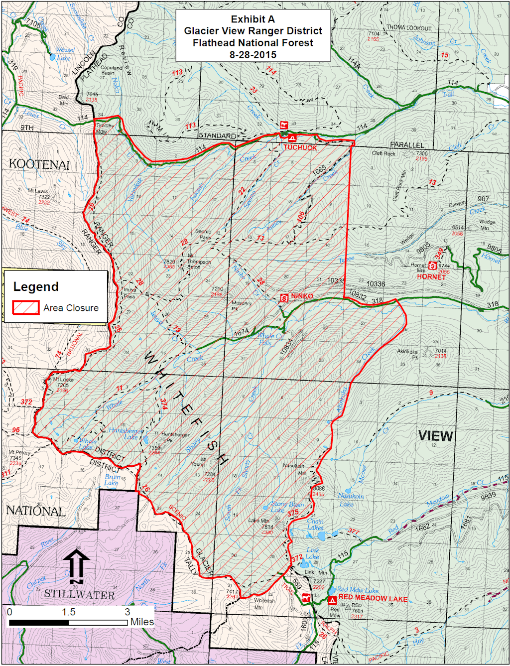
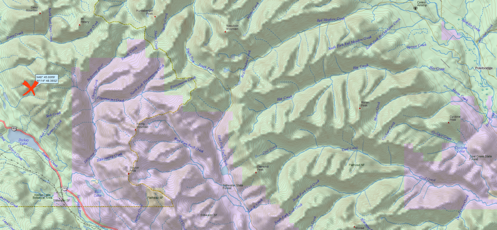
It’s official. The Forest Service is closing an area of the Flathead National Forest in the North Fork as a precautionary measure in case the Marston Blaze comes over the Whitefish Divide. This is not terribly likely, but the fire weather is a big concern over the next couple of days.
As near as I can tell from the map, only two roads are affected. Trail Creek Road is now closed just west of the Tuchuck Campground. Whale Creek Road is closed about four miles past the turnoff for the Hornet Lookout. At present, Red meadow Road is unaffected.
Note this item from the “Special Messages/Closures” section: “A new Area Closure for the Hungry Horse Ranger District, Flathead National Forest is being developed in anticipation of the Marston Fire moving into the area and will be posted on InciWeb when finalized today.” It now appears that Whale Creek Road will, in fact, be closed.
Information Officers: Katie Knotek, Tom Rhode & Meg Nemitz Fire Information Line: (406) 882-8308 Office hours: 8:00 a.m. to 8:00 p.m. Email:northeastkootenaicomplex@gmail.com
INCIDENT: Northeast Kootenai Complex (includes Barnaby, Marston, and Sunday Fires) AGENCY JURISDICTION: USDA Forest Service, Kootenai & Flathead National Forests; Montana DNRC, Libby and Stillwater Units. INCIDENT COMMANDER: Shawn Pearson, Northern Rockies Type II Incident Management Team (IMT). The Incident Command Post (ICP) is located at the Murphy Lake Ranger Station.
WEATHER & FIRE BEHAVIOR: A Red Flag Warning is issued for today due to a break in the valley inversion and smoke cover, continued hot (80s), dry (relative humidity 16-21%) conditions and wind gusts out of the southwest up to 20 mph in the late afternoon. Fire behavior will be active today with short crown runs.
MARSTON FIRE:
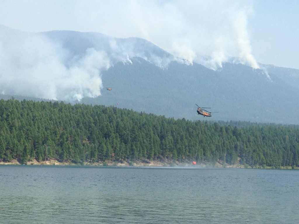
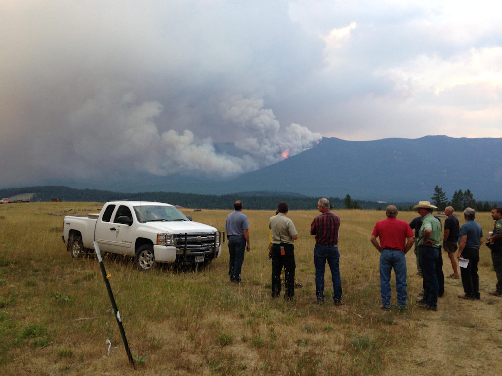
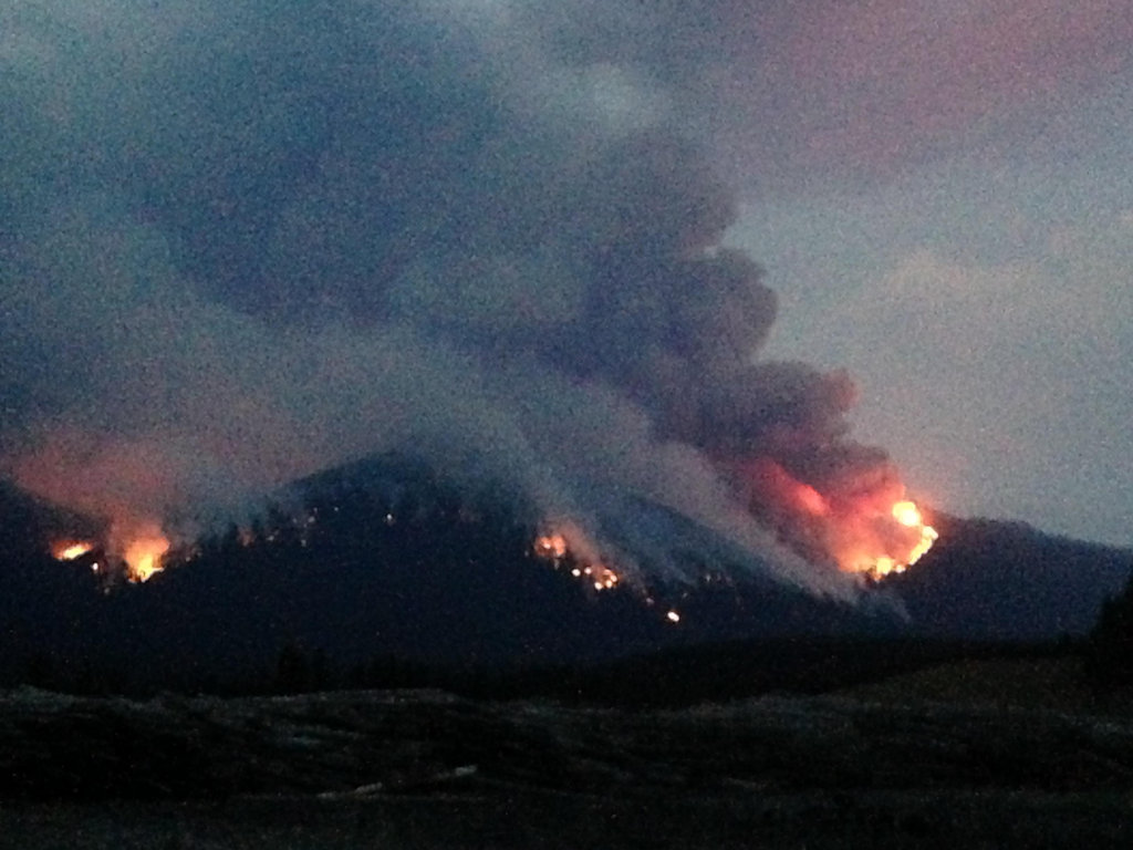
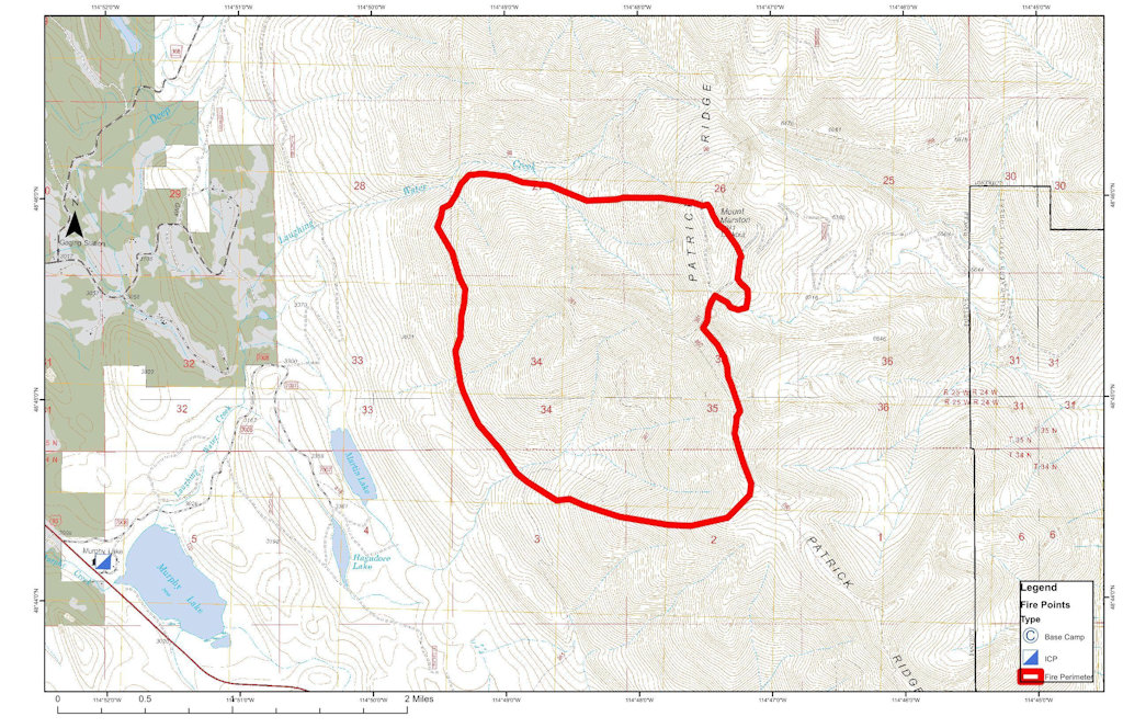
The Marston Fire is estimated at 4,790 acres with 5% containment. The fire increased in size yesterday, but an infrared flight was not available to provide accurate mapping of the current fire perimeter. Fire growth was primarily to the east towards the Flathead National Forest and the Stillwater State Forest. On the north end of the fire, Hotshot crews worked on checking fire spread as it backed downhill, and feller bunchers continued to work on indirect line construction along Deep Creek. These operations will continue today as conditions permit. On the fire’s west side, crews will continue to blacken and secure fireline to the south and check fire spread as it moves downhill. Heavy equipment work constructing fuel breaks south of the fire and east towards the Stillwater State Forest will continue.
SUNDAY FIRE:
The Sunday Fire located about four miles southeast of Stryker, MT, is 60 acres with 100% containment. A Palm IR (Infrared) unit will be used today to check for any remaining hot spots on the fireline. There is no longer a threat of evacuation for local residents in the vicinity of the Sunday Fire and the Population Protection Plan has been removed from Inciweb.
BARNABY FIRE:
The Barnaby Fire is located about four miles northeast of Eureka in steep, rugged terrain. The fire is being monitored from the air with bucket drops from helicopters when possible. Strong valley inversions and smoke cover have prevented aerial observation and bucket drops on the fire for the last several days. The fire remains 50 acres with 0% containment.
PERSONNEL AND RESOURCES: 348 personnel including 3 Type -1 crews, 5 Type – 2 crews, 12 engines,
3 helicopters (2 Type – 1 Chinooks, 1 Type – 2), 6 dozers, 9 water tenders, and 4 skidgines.
SPECIAL MESSAGES/CLOSURES: There is an area closure for both the Martson and Barnaby Fires. The Marston Fire Area Closure includes closure of Murphy Lake for the safety of both firefighting equipment and the public, as helicopters dip out of Murphy Lake for water drops on the Martson Fire. See Inciweb for maps and explanations of these closures. A new Area Closure for the Hungry Horse Ranger District, Flathead National Forest is being developed in anticipation of the Marston Fire moving into the area and will be posted on InciWeb when finalized today.
The Incident Management Team will have a booth at the Lincoln County Fair this weekend. A Community Meeting will be held Sunday evening, August 30, at 7:00 p.m. at the Trego Civic Center.
For more information on the fires, visit: http://inciweb.nwcg.gov/; Select “Northeast Kootenai Complex”
The Forest Service is going to close Whale Creek Road due to the run the Marston Fire made. Apparently, they are worried it might cross the Whitefish Divide.
Today and tomorrow are going to be bad fire weather days. At 10:33 am a Red Flag warning was issued for tomorrow (Saturday, August 29) with 45mph winds and 10% relative humidity.
Here is the official morning report on the wildfires in the Northeast Kootenai Complex, including the Barnaby, Marston, Sunday and Weigel blazes.
Although the Marston Fire is a potential threat if things go seriously awry, the only impact these fires presently have on the North Fork is the closure of the Trail Creek Road at the Kootenai Forest boundary . . .
AGENCYJURISDICTION: USDA Forest Service, Kootenai & Flathead National Forests; Montana DNRC, Libby and Stillwater Units.
INCIDENTCOMMANDER: Shawn Pearson, Northern Rockies Type II Incident Management Team (IMT). The Incident Command Post (ICP) is located at the Murphy Lake Ranger Station.
WEATHER & FIRE BEHAVIOR: Warm, sunny and dry day with light winds will increase fire activity in the afternoon today. A warm and dry trend will continue through the week; a Fire Weather Watch has been issued for Monday.
MARSTON FIRE:
The Marston Fire is estimated at 3,200 acres with 5% contained and is located about three miles southeast of Fortine, MT. Dozer and hand line have been completed along the fire’s western edge and north to Deep Creek drainage. Crews are now working on opening roads for access to the fire’s northeast side near the mouth of Deep Creek. Dozer line has been completed from Laughing Water Creek to Sink Creek and crews will work on laying hose to supply water to the line. Indirect line is being scouted for the east side of the fire adjacent to the Stillwater State Forest. Helicopters will drop water on the southeast and northwest corners of the fire again. The fire may become more active throughout the week with warmer temps and low humidity, residents are asked to stay informed of changing fire conditions. The population protection plan is still in place for residents living near Laughing Water, Deep and Grave Creeks. This determines when evacuations would take place in the vicinity of the Marston Fire. A copy of the plan can be found on the Northeast Kootenai Complex Inciweb page (link listed below). No evacuations are currently in effect.
SUNDAY FIRE:
The Sunday Fire located about four miles southeast of Stryker, MT, is at 60 acres with 90% contained. Fireline has been constructed around the fire perimeter, and crews are working on mopping up and cooling hot spots within the fire’s perimeter. The population protection plan is still in place and determines when evacuations would take place in the vicinity of the Sunday Fire. A copy this plan can be found on the Northeast Kootenai Complex Inciweb page (link listed below). No evacuations are currently in effect.
BARNABY FIRE:
The fire is located about four miles northeast of Eureka in very steep and rugged terrain. Fire activity has been minimal in the last two days with the cooler weather and has stayed at about 40 acres with 0% containment. A Type 1 helicopter will be available to drop water as needed.
PERSONNELAND RESOURCES: 320 personnel including 1 Type 1 crew, 5 Type 2 crews, 16 engines,
Helicopters: 2 Type 1, 1 Type 2, and 1 Type 3, 6 dozers, 8 water tenders, 4 skidgines, and .
SPECIALMESSAGES/CLOSURES: There is an area closure for the Barnaby Fire as well as for the Marston Fire. See Inciweb for maps and explanations of these closures. There will be a public meeting in Trego at the Civic Center on Monday August 24th at 7:00PM.
Residents in Lincoln County interested in signing up for reverse 911 or “Code Red” can visit this website for further information: http://www.lincolncountymt.us/
Formoreinformation on the fires, visit: http://inciweb.nwcg.gov/; Select “Northeast Kootenai Complex”
Trail Creek Road is presently closed at the Kootenai National Forest boundary — i.e., at Trail Creek Pass. This is part of the general area closure associated with the Marston Fire. The fire is not moving towards the North Fork at this time.
AGENCYJURISDICTION: USDA Forest Service, Kootenai & Flathead National Forests; Montana DNRC, Libby and Stillwater Units.
INCIDENTCOMMANDER: Shawn Pearson, Northern Rockies Type II Incident Management Team (IMT). The Incident Command Post (ICP) is located at the Murphy Lake Ranger Station.
WEATHER & FIRE BEHAVIOR: A red flag warning is in effect for today due to windy conditions and the possibility of thunderstorms. A cold front will move into the area around 2pm, bringing wind and possible lightning. This evening around 8 or 9pm, a second cold front will move into the area with shifting winds from the north to northeast and up to 1/10th of an inch of rain. Weekend weather will be dry with cooler temperatures.
MARSTON & BARNABY FIRES:
The Marston Fire is estimated at 3,200 acres and the Barnaby fire at 40 acres. Both fires are located near Eureka, MT on the Fortine Ranger District, Kootenai National Forest. Today on the Marston Fire, crews will begin to secure the line along the eastern edge of the fire. They will also begin to put dozer line near the southeast edge of the perimeter to prevent the fire’s spread into the Stillwater State Forest. The structure group will finish their structure assessment of properties in the Laughing Water Creek and Graves Creek areas. A population protection plan has been established to determine when evacuations would take place in the vicinity of the Marston Fire if the need arises. A copy of the plan can be found on the Northeast Kootenai Complex Inciweb page (link listed below). No evacuations are currently in effect. The Barnaby Fire will continue to be monitored with the National Guard Chinooks available for water drops when needed.
WEIGEL FIRE:
The Weigel Fire is 100% contained and has been returned to Montana DNRC management.
SUNDAY FIRE:
The Sunday Fire is estimated at 60 acres. The Sunday fire is located on the Fortine Ranger District, Kootenai National Forest. Fireline has been constructed around the majority of the fire perimeter. Crews will complete fireline today and continue to wet hotspots. A population protection plan has been established to determine when evacuations would take place in the vicinity of the Sunday Fire. A copy of the plan can be found on the Northeast Kootenai Complex Inciweb page (link listed below). No evacuations are currently in effect.
General Quinn and staff of the Montana National Guard, as well as a staffer from Governor Bullock’s office, visited Helibase yesterday to see how the 2 National Guard chinooks were assisting with firefighting efforts. They have been dropping water on the Marston and Barnaby Fires and will continue these efforts today.
PERSONNELAND RESOURCES: 331 personnel, including 3 – Type 1 crews, 4 – Type 2 crews, 16 engines, 2 Type 1 helicopters, 1 Type 3 helicopter, 6 dozers, 2 excavators, 3 feller-bunchers, and 8 water tenders.
SPECIALMESSAGES/CLOSURES: A new area closure is in effect for the Barnaby Fire in addition to the closure for the Marston Fire. See Inciweb for maps and explanations of the closures. A community meeting will be held tonight, August 21, at the Eureka High School at 7:00 p.m.
A cluster of wildland fires on the west side of the Whitefish Divide is now being handled as the “Northeast Kootenai Complex” under the control of Shawn Pearson’s Type II Incident Management Team. By far the largest fire in this group — and the one of primary interest on the North Fork — is the Marston Fire. Others include the Barnaby, Sunday, Weigel and Dunn blazes.
Information Officers: Claire Pitner, Katie Knotek, Tom Rhode & Meg Nemitz
Fire Information Line: (406) 882-8308
Office hours: 8:00 a.m. to 8:00 p.m.
Email: northeastkootenaicomplex@gmail.com
INCIDENT: Northeast Kootenai Complex; The complex includes the Barnaby, Marston, Sunday, Weigel and Dunn Fires.
AGENCY JURISDICTION: USDA Forest Service, Kootenai & Flathead National Forests; Montana DNRC, Libby and Stillwater Units.
INCIDENT COMMANDER: Shawn Pearson, Northern Rockies Type II Incident Management Team (IMT). The Incident Command Post (ICP) is located at the Murphy Lake Ranger Station.
WEATHER & FIRE BEHAVIOR: Weather today will be similar to yesterday with cooler temperatures (mid-70s) and higher relative humidity (20-30%). This will continue to moderate fire behavior on all fires, with little to no fire growth expected.
MARSTON & BARNABY FIRES: The Marston Fire is estimated at 1,500 acres and the Barnaby Fire at 5 acres. Both fires are located near Eureka, MT on the Fortine Ranger District, Kootenai National Forest. Today on the Marston Fire, firefighters will continue work on a fuel break on the east side of Deep Creek. On the Barnaby Fire, a Hotshot crew will hike into the fire area to assess the situation and plan for future operations. No evacuations are currently in effect for either of these fires.
WEIGEL & DUNN FIRES: The Weigel Fire is approximately 100 acres and the Dunn Fire is 74 acres. Both fires are located near Libby, MT on the Libby Ranger District, Kootenai National Forest. Fireline has been established around the full perimeter of each fire. Today, firefighters will continue wetting along the fireline and into the fire perimeter.
SUNDAY FIRE: The Sunday Fire is approximately 150 acres and is located on the Tally Lake Ranger District, Flathead National Forest and Fortine Ranger District, Kootenai National Forest. Fireline has been constructed around a good portion of the fire perimeter. The focus today will be to snag hazard trees in the fire area before completing the remaining line construction.
PERSONNEL AND RESOURCES: 224 personnel, including 2 – Type 1 crews, 2 – Type 2 crews, 16 engines, 7 dozers, 3 feller-bunchers, 6 skidgons and 6 water tenders.
SPECIAL MESSAGES/CLOSURES: An area closure is in effect for the Marston Fire and is posted on Inciweb. A community meeting will be held tonight at the Trego Civic Center at 7:00 p.m.
The Kootenai National Forest is scrambling to deal with a number of new wildfires . . .
The Kootenai National Forest added 14 new fires Saturday to its growing list that totals 49 wildfires that have started since Aug. 1.
Lightning raked the forest Friday night, igniting new fire starts.
The largest fire — the Marston Fire near Trego — had grown to 1,500 to 1,800 acres as of Saturday afternoon, according to Kootenai National Forest Public Information Officer Willie Sykes.
Here’s the noon update on the Marston Fire. Short version: The blaze is up to about 1500 acres. Shawn Pearson’s Type II team will be taking over tomorrow (Sunday) morning, which means they are taking this fire pretty seriously.
FIRE UPDATE
Marston Fire
Fortine Ranger District, Kootenai National Forest
August 15, 2015, 12:00 p.m.
Fire Information Line: (406) 882-8308 starting August 15
Office Hours: 8:00 a.m. to 8:00 p.m.
What: Wildland Fire Detected: August 11, 2015 Cause: Lightning Current Size: Estimated 1,500 Acres Containment: 0% Resources on Fire: 3 feller bunchers, 2 skidders, 1 dozer, 2 dozer bosses, 1 dozer boss trainee, 15 district fire personnel Location: Approx. 15 miles SE of Eureka, MT on the Fortine District of the Kootenai National Forest.
Status: Due to steep terrain, extremely dry fuels, high temperatures and low humidities, the fire grew significantly yesterday. Firefighters worked on establishing a contingency line in the Laughing Water/Summit Creek area with feller bunchers and dozers. Local district personnel responded to several lightning strikes/new fire starts with initial attack. A trace of rain fell on the fire overnight.
Today the weather is expected to be overcast with cooler temperatures (60-70° degrees) and a higher relative humidity. These conditions should moderate fire behavior. Firefighters are working on building a fuel break on the East side Deep Creek.
Shawn Pearson’s Northern Rockies Type 2 Incident Management Team is onsite at the Fortine Ranger District and will be transitioning with the district personnel. The team is expected to take command of the fire on Sunday, August 16.
Special Messages/Closures: The top priority is firefighter and public safety. Closures in the Marston face area, Stillwater area, and Laughing Water area remain in effect. An expanded area closure went into effect early this morning and is posted on inciweb.There are no evacuations in effect at this time.
There will be a community meeting at the Trego Community Hall at 7:00 pm on Sunday evening, August 16.
The Marston Fire ballooned up to 1200 acres. A Type II team is due on site tomorrow (Sunday) morning . . .
As many as 26 new fires had been reported in the Kootenai National Forest area by Friday evening, with a previously reported pair of fires on Mount Marston erupting to cover 1,200 acres.
The two fires were being managed as a single incident dubbed the Marston Fire and are burning about two miles northeast of Dickey Lake and four miles northeast of Trego.
The fires are threatening the Mount Marston Lookout.