Bat-killing disease reported in West for first time

Little brown bat affected by White nose syndrome - Marvin Moriarty-USFWS
Little brown bat affected by White nose syndrome – Marvin Moriarty-USFWS

The Flathead Valley along both sides of the border is a significant bat study area, so the first report of white-nose syndrome in the Western U.S. is worrying . . .

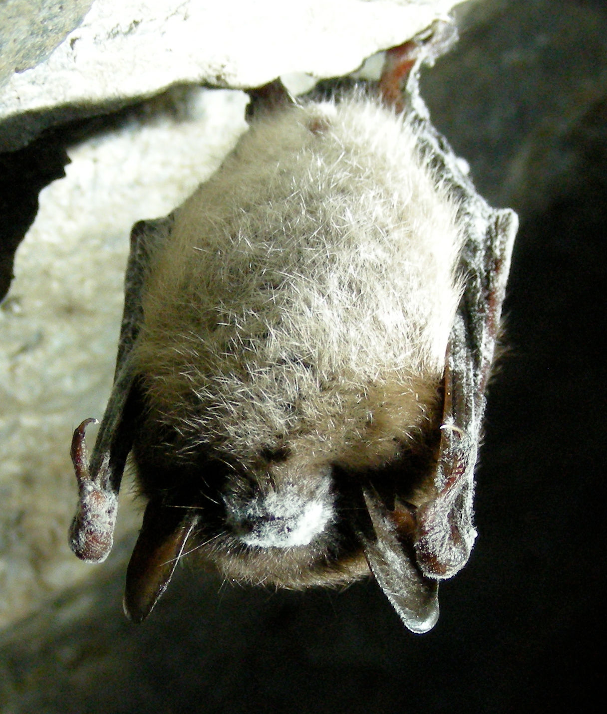
A hiker found a bat with deadly white-nose syndrome along a trail east of Seattle, marking the first time the fungus-borne disease has appeared in the western United States.

“It’s very disheartening to see this long a jump,” said Chris Servheen of the U.S. Fish and Wildlife Service, which monitors the spread of white-nose syndrome. “It was documented by North Bend, Washington, and the closest evidence of white-nose before this was eastern Nebraska and northern Minnesota.”

The little brown bat was found on March 11 in an area not known for caves or hibernaculum, where large colonies of bats gather to hibernate through the winter. The fungus typically creates a powdery coating on a hibernating bat’s nose and mouth, depriving it of the energy it needs to survive the winter. It spreads from nose to nose in the densely packed confines of bat colonies.

Read more . . .

New specialty license plate features North Fork Flathead

'Wild Rivers' license plate featuring North Fork Flathead
‘Wild Rivers’ license plate featuring North Fork Flathead

American Rivers is behind a new Montana specialty license plate featuring the North Fork of the Flathead River . . .

How can license plates help river conservation? When you purchase a new “Wild Rivers” specialty license plate in Montana, the Northern Rockies Office of American Rivers receives a $25 donation that we use to protect wild rivers, restore damaged rivers, and conserve clean water for people and nature across the state.

American Rivers’ Northern Rockies Office commissioned Bozeman artist and outdoor athlete Rachel Pohl to create the stunning painting that appears on the plate, depicting the Wild and Scenic North Fork of the Flathead River along the western boundary of Glacier National Park. Rachel employs bold colors and vibrant imaging in her paintings, capturing the feel of mountain landscapes and making them jump off the canvas. The scene that she evokes in this painting is no different: A mother grizzly and two cubs overlook a whitewater rapid along the North Fork Flathead River, set beneath a fiery sunrise framing the Livingston Range.

Read more . . .

North Fork Road improvement project takes another step forward

North Fork Road, March 17, 2016 - W. K. Walker
North Fork Road, March 17, 2016 – W. K. Walker

It’s official now: If everything falls into place, we could see quite a bit of road work in the neighborhood within a couple of years . . .

The Flathead County Commission voted unanimously on March 24 to move forward with a proposed project among the county and federal partners to rehabilitate the North Fork Road.

The project, part of the Montana Federal Lands Access Program (FLAP), seeks to make improvements to the road, which serves as an access point for about 300 residents and thousands of recreationists each year.

FLAP was established to improve transportation routes that provide access to, are adjacent to, or located within federal lands. The program supplements state and local resources for public roads and transit systems. The North Fork project is still in the application phase.

Read more . . .

Glacier Park still on schedule to begin plowing snow April 1

Rotary snowplow at work - Glacier NP photo
Rotary snowplow at work – Glacier NP photo

Glacier Park is still on-schedule to begin snow removal on April 1, starting with Camas Road. The Flathead Beacon has a good write-up . . .

The true mark of spring’s arrival in the Flathead Valley, the plows in Glacier National Park are rumbling to life this week to embark on the monumental task of clearing Going-to-the-Sun Road.

Park crews are slated to start April 1 with the Camas Road before turning their attention to the park’s iconic 52-mile thoroughfare. Clearing the narrow two-lane road is a challenging task that usually takes 10 weeks depending on weather conditions and snowpack levels. The mountain highway is considered one of the most difficult roads in America to plow. In years past, crews have been hampered by avalanches and significant obstacles, such as the Big Drift, a one-mile section of Sun Road near Logan Pass where typically over 100 feet of snow accumulates in winter.

The current snowpack levels are at 96 percent of average, according to the Flattop Mountain SNOTEL site, a U.S. Geological Survey site sitting at 6,300 feet elevation in the park.

Read more . . .


To monitor road status: http://home.nps.gov/applications/glac/roadstatus/roadstatus.cfm

To see where the plows are: http://home.nps.gov/applications/glac/gttsroadplow/gttsroadplowstatus.cfm

Project could return bison to Glacier Park, Badger-Two Medicine

Bison grazing
Bison grazing

From this week’s Hungry Horse News . . .

Back in 1872 a Salish and Kootenai Warrior named Running Coyote was on the outs with the tribe. He had a wife on one side of the divide and a Blackfeet wife on the other side of the divide.

In an attempt to make amends, Running Coyote along with Blackfeet Warriors Greengrass Bull, Boy Chief and Calf Tail captured several buffalo calves near Buffalo Lake on Blackfeet lands and took them over the Continental Divide to the Salish and Kootenai as a gift.

It didn’t work out for Running Coyote, he still wasn’t forgiven. But the buffalo remained and two other men, Michel Pablo and James Allard took possession of the herd. About 26 years later, the reservation was opened up to homesteading and the free-ranging herd of about 300 animals had to go.

Read more . . .

116 conservation organizations, including NFPA, sign letter opposing bikes in wilderness

Mountain Biker by Mick Lissone

The NFPA joined a large group of other conservation organizations in signing on to a letter to congress opposing any change to the Wilderness Act that would permit bicycles in wilderness areas . . .

A legal change to allow bikes in federal wilderness hasn’t been introduced in Congress yet, but the issue already has advocates riled and rolling.

Last week, a coalition of conservation groups published a letter asking congressional delegations to “reject calls to amend the Wilderness Act to allow for the use of mountain bikes in designated Wilderness.” The coalition included Montana-based Wilderness Watch, Bitterroot Backcountry Horsemen of Montana and North Fork Preservation Association, among others.

They aimed their concern at proposed legislation drafted by a national mountain-biking group called Sustainable Trails Coalition, which also claims members in Montana. STC President Ted Stroll said the bill would move the decision about allowing bicycles in wilderness or proposed wilderness areas to the local forest supervisor level, instead of the national agency headquarters. It would also allow federal land managers to use mechanized and wheeled tools to maintain trails in federal wilderness.

Read more . . .

Letter: Keep bikes out of wilderness (PDF, 102KB)

Scientists to present Flathead deep aquifer research

There’s an interesting presentation on the Flathead Valley’s hydrology coming up on April 6 at Flathead Valley Community College, in the Arts and Technology building theater at 6:30 pm . . .

When Flathead Valley residents turn on their tap water, they often take it for granted. But with the exception of those living in Whitefish, most everyone living in the valley relies on groundwater from a series of deep aquifers known as the Flathead Valley deep aquifer.

It’s the most widely used aquifer in the valley, supplying high-capacity municipal and irrigation wells in addition to thousands of domestic wells. The deep aquifer is a thick deposit of gravel and sand, the top of which is 75 to over 400 feet deep and separated from shallow units and the land surface by a thick confining unit.

On April 6, research hydrogeologists John Wheaton and James Rose from the Montana Bureau of Mines and Geology will present their research on the Flathead Valley’s deep aquifer and discuss the long-term sustainability of the area’s groundwater resources.

Read more . . .

Forest Service extends comment period for Rock Creek Mine

The public now has extra time to make their views known about the proposed Rock Creek Mine . . .

The U.S. Forest Service has extended the comment period for the draft environmental impact statement for the Rock Creek Mine project near Noxon.

Residents will now have until April 19 to submit comments on the proposed copper and silver project. Kootenai National Forest officials said in a press release announcing the extension that they wanted to give people more time to review the draft supplemental environmental impact because it is a “complex document.”

The draft study released in February addresses concerns about sediment control and ground water at Rock Creek.

Read more . . .

Annual Bob Marshall Wilderness Complex public meeting April 2

Chinese Wall - Bob Marshall Wilderness
Chinese Wall – Bob Marshall Wilderness

From the official press release . . .

The public is invited to the annual Bob Marshall Wilderness Complex (BMWC) Public Meeting on Saturday, April 2 starting at 10 AM at the Stage Stop Inn in Choteau, Montana.

“This is a great annual opportunity to meet with the National Forest Wilderness Managers and Montana Fish and Wildlife staff”, says Deb Mucklow, Spotted Bear District Ranger. “The challenges of managing wilderness are often not understood. Historically the participants at this annual meeting have helped with solutions or ideas that we as managers may be to incorporate. Specific updates will be shared from the Fire Season of 2015, the Wilderness Stewardship Performance program, and specific trail needs/projects, wilderness issues and more.” All of the participants will be encouraged to interact with the managers present and have time for one on one questions. We’ll also be asking how they value the wilderness we have today and what the expectations are for the future. In addition, updates will be provided on specific activities and projects, and ongoing monitoring across the Bob Marshall Wilderness Complex. The monitoring and actions are a piece of the Limits of Acceptable change for the Bob Marshall Wilderness Complex (BMWC).”

Continue reading Annual Bob Marshall Wilderness Complex public meeting April 2

Glacier Park to start plowing; Camas Road is first

Rotary snowplow at work - Glacier NP photo
Rotary snowplow at work – Glacier NP photo

Glacier Park will fire up the snowplows on April 1, with the Camas Road being first in line for attention on the west side.

Since they will likely be able to plow it with a push broom this year, Camas Road should be open in very short order.

To monitor road status: http://home.nps.gov/applications/glac/roadstatus/roadstatus.cfm

To see where the plows are: http://home.nps.gov/applications/glac/gttsroadplow/gttsroadplowstatus.cfm