The Essex evacuation order was lifted this morning and U.S. Route 2 was reopened. In general, cooler, wetter weather has helped firefighters throughout the region . . .
The residents of Essex can go home again, if they’re ready to.
Flathead County Sheriff Chuck Curry announced Sunday night that the mandatory evacuation order for the town will be lifted at 6 a.m. Monday morning, and the community will be back to the “set” stage of the “Ready, Set, Go” evacuation model.
Essex had been under a mandatory evacuation order since Thursday, as the Sheep fire closed in. Also, U.S. Highway 2 will reopen at the same time, with pilot cars escorting traffic through the fire zone.
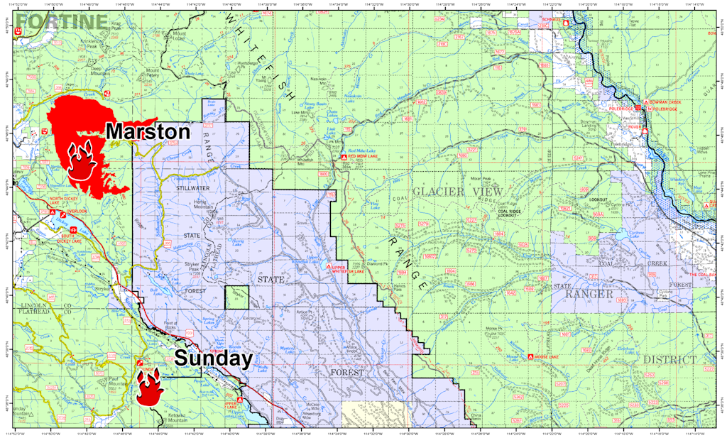
Of greatest interest to North Forkers is the Marston Fire, which made a run to the northeast recently, resulting in a precautionary closure of a section of the Flathead National Forest in the North Fork. The cooler, wetter weather that moved into the area has made life easier for crews fighting this blaze. It is still not anywhere close to the North Fork.
Information Officers: Katie Knotek, Tom Rhode & Meg Nemitz Fire Information Line: (406) 882-8308 Office hours: 8:00 a.m. to 8:00 p.m. Email:northeastkootenaicomplex@gmail.com
INCIDENT: Northeast Kootenai Complex (includes Barnaby, Marston, and Sunday Fires) AGENCY JURISDICTION: USDA Forest Service, Kootenai & Flathead National Forests; Montana DNRC, Libby and Stillwater Units. INCIDENT COMMANDER: Shawn Pearson, Northern Rockies Type II Incident Management Team (IMT). The Incident Command Post (ICP) is located at the Murphy Lake Ranger Station.
WEATHER & FIRE BEHAVIOR: Weather today will be cloudy with maximum temperatures 57 to 65 F, relative humidity 45 to 52%, and southwest winds 2 to 8 mph. Based on these conditions, moderate fire behavior is expected. On the Marston Fire, fire will continue the slow process of backing downhill toward Deep Creek on the North and Sink Creek on the South.
MARSTON FIRE:
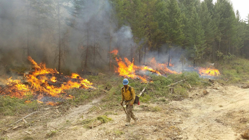
The Marston Fire is estimated at 6,700 acres with 15% containment. On the North side of the fire, crews are working in the bottom of Deep Creek preparing fireline and fuel breaks in preparation for the fire backing down to the creek east of Jeager Mine. Nine miles of fuel break, from Deep Creek south to near Sink Creek, has held and is keeping the fire from moving west. On the south side of the fire, excavators are being used to pile logs along the indirect line that runs south and east to the Stillwater State Forest. A Montana National Guard Chinook helicopter and a medium helicopter will be available with water drops to assist firefighters with cooling hot spots along the fire’s edge. The fire has NOT moved onto the Flathead National Forest and is approximately 20 miles away from Polebridge. Residents who are concerned about the fire are asked to contact the Northeast Kootenai Complex Fire Information Line and stay updated on the incident through the InciWeb site for the Northeast Kootenai Complex.
SUNDAY FIRE:
The Sunday Fire located about four miles southeast of Stryker, MT, is 60 acres with 100% containment and is being patrolled daily to check for hotspots.
BARNABY FIRE:
The Barnaby Fire is located about four miles northeast of Eureka in steep, rugged terrain. The fire is being monitored from the air with helicopters available to drop water as needed. Fire remains 50 acres, 0% containment.
PERSONNEL AND RESOURCES: 285 personnel including 2 Type -1 crews, 4 Type – 2 crews, 6 engines,
2 helicopters (1 Type – 1 Chinook, 1 Type – 2), 2 dozers, 5 water tenders, and 4 skidlines.
SPECIAL MESSAGES/CLOSURES: There are Area Closures on the Fortine Ranger District, Kootenai National Forest, for both the Martson and Barnaby Fires. The Marston Fire Area Closure includes closure of Murphy Lake for the safety of firefighting equipment and the public, as helicopters dip water out of the lake. There is an additional Area Closure for the Marston Fire on the Hungry Horse-Glacier View Ranger District, Flathead National Forest, should the fire move into the area. See Inciweb for maps and explanations of closures.
For more information on the fires, visit: http://inciweb.nwcg.gov/; Select “Northeast Kootenai Complex”
Information Officers: Katie Knotek, Tom Rhode & Meg Nemitz Fire Information Line: (406) 882-8308 Office hours: 8:00 a.m. to 8:00 p.m. Email:northeastkootenaicomplex@gmail.com
INCIDENT: Northeast Kootenai Complex (includes Barnaby, Marston, and Sunday Fires) AGENCY JURISDICTION: USDA Forest Service, Kootenai & Flathead National Forests; Montana DNRC, Libby and Stillwater Units. INCIDENT COMMANDER: Shawn Pearson, Northern Rockies Type II Incident Management Team (IMT). The Incident Command Post (ICP) is located at the Murphy Lake Ranger Station.
WEATHER & FIRE BEHAVIOR: Today, fire behavior is expected to decrease with the cold front moving through the area. Strong winds are predicted (gusts to 30+mph), however, temperatures will decrease to the low 60s with relative humidity increasing.
MARSTON FIRE:
The Marston Fire is estimated at 6,500 acres and containment has dropped back to 5% with the additional growth to the northeast. On the north side of the fire, crews are working in the bottom of Deep Creek preparing fireline and fuel breaks for when the fire backs down to the creek east of Jeager Mine. Nine miles of fuel break from Deep Creek south to near Sink Creek has held and is keeping the fire from moving west, while crews continue preparing line south and east to the Stillwater State Forest. A medium helicopter will be available to drop buckets of water as air/smoke conditions allow to assist firefighters with slowing the fire’s progression. The fire has NOT moved onto the Flathead National Forest and is approximately 20 miles away from Polebridge. Residents who are concerned about the fire are asked to contact the Northeast Kootenai Complex Fire Information Line and stay updated on the incident through the InciWeb site for the Northeast Kootenai Complex.
SUNDAY FIRE:
The Sunday Fire located about four miles southeast of Stryker, MT, is 60 acres with 100% containment and is being patrolled daily to check for hotspots.
BARNABY FIRE:
The Barnaby Fire is located about four miles northeast of Eureka in steep, rugged terrain. The fire is being monitored from the air with helicopters available to drop water as needed. Fire remains 50 acres, 0% containment.
PERSONNEL AND RESOURCES: 300 personnel including 2 Type -1 crews, 4 Type – 2 crews, 10 engines, 3 helicopters (2 Type – 1 Chinooks, 1 Type – 2), 4 dozers, 9 water tenders, and 4 skidgines.
SPECIAL MESSAGES/CLOSURES: There is an area closure for both the Martson and Barnaby Fires. The Martson Fire Closure includes closure of Murphy Lake for the safety of both firefighting equipment and the public, as helicopters dip out of Murphy Lake for water drops on the Marston Fire. A new Area Closure for Hungry Horse Ranger District, Flathead National Forest has been issued. See Inciweb for maps and explanations of closures.
A community meeting will be held this evening August 30, at 7:00 p.m. at the Trego Civic Center.
For more information on the fires, visit: http://inciweb.nwcg.gov/; Select “Northeast Kootenai Complex”
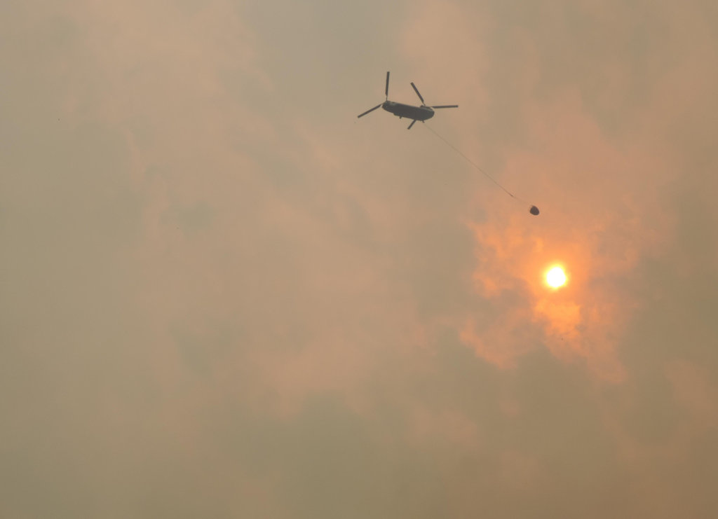
Helicopter conducts water drop operations on the Sheep Fire, 29 Aug, 2015
Here’s the morning update for the Thompson-Divide Complex fires.
The big news continues to be the Sheep Fire, which is threatening Essex. Essex is under a mandatory evacuation order and US Route 2 is closed in the immediate vicinity . . .
Evacuation and Highway Closure Information: Flathead County EOC, (406) 758-2111, 8 a.m.-10 p.m.
Resources – Total Personnel: 316 Injuries: 1 Structures Lost: None
20-Person Hand Crews: 1 Type-1 and 3 Type-2, 1 Wildland Fire Management Module (8), 1 Helitack Crew (10)
Air Support: Helicopters (2 Type-1 & 2 Type-3), Engines: 17 Heavy Equipment: 15
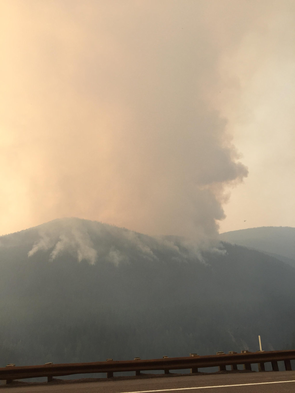
The Thompson-Divide Complex is comprised of the Sheep and Granite Fires on the Flathead National Forest and the Thompson Fire in Glacier National Park. The Sheep fire is the incident priority as it is approaching US Hwy. 2 and the BNSF railway and is threatening the community of Essex.
On Aug. 27, Flathead County Sheriff Chuck Curry ordered a mandatory evacuation of Essex and the surrounding area because of increased activity on the Sheep Fire. For more information on the evacuation, call the Flathead County Office of Emergency Services at (406) 758-2111. The American Red Cross has established an evacuation center at West Glacier Elementary School at 160 Old Bridge Rd., (800) 272-6668.
Highway 2 is closed between mileposts 176.8 at Schellinger and 185 at Bear Creek. BNSF trains and Amtrak are running intermittently. Call 511 or visit http://www.mdt.mt.gov/travinfo/alerts.shtml for current road status. For more information on Amtrak call (800) 872-7245.
Stage II Fire Restrictions are in effect for northwestern Montana.
Closures are in effect for some trails in the vicinity of the fires for Glacier National Park and Flathead National Forest. For more info, please see the Glacier NP page http://www.nps.gov/glac/upload/8-22-15-closures-web.pdf or for Flathead NF call Hungry Horse Ranger District (406) 387-3800. An area closure around the Granite and Sheep Fires in the Great Bear Wilderness is in place. Contact Hungry Horse Ranger District for more information. The order and map are posted at http://inciweb.nwcg.gov/incident/article/4468/28364/.
The predicted cold front arrived in the fire area by mid-afternoon yesterday. Peak winds did not reach the levels anticipated. Today, the fire area will have mostly cloudy conditions with chances of showers and afternoon thunderstorms. The NW Park area did experience some trace amounts of rain over night. Temperatures will be reduced and humidity higher with SW winds of 15-25 mph switching to NW this afternoon. General fire behavior is expected to be moderated.
Sheep Fire, Flathead National Forest
Structures At Risk: 200+ structures, BNSF has several wooden snowsheds and 1 trestle, utilities infrastructure
Fire Update: The Sheep Fire is on the Flathead National Forest and burning in very steep terrain with limited access. The fire is about 1 mile south of Essex and about 1/8 mile from the train tracks between Tank Creek and MacDonald Creek. The fire has not crossed Sheep Creek to the south. Moderated fire activity will likely allow direct suppression efforts in the Sheep Creek area. Construction of the shaded fuel break around Essex is near completion. The logs and slash created by this effort are being moved to a safe location. Crews will begin reducing fuels along Essex Creek Road to the Marion Bridge using a feller-buncher to make this position more defensible if burning operations are required later. Crews may also begin fuels reduction efforts on County park land on the south side of Essex. Helicopters may have visibility problems early with haze and fog that may delay support operations with water drops and logistical shuttle missions. Structural protection measures are in place in Essex. Night shift continues to monitor fire movement and patrol the Essex area and Walton compound for any encroaching fire activity.
First fires, now bears. The St. Mary area of Glacier Park has had its problems this summer . . .
It will be hard-sided camping only for now at St. Mary Campground on the east side of Glacier National Park.
Bears in search of berries in the area are “creating a high potential for negative human-bear interactions,” park officials said Friday.
RVs, motorhomes, trailers and hard-sided pop-ups will be allowed in the campground, as will camper vehicles such as Volkswagen buses and pickup trucks with small canvas pop-ups “as long as the canvas is not exposed,” Glacier spokeswoman Katelyn Liming said.
Here’s a quick afternoon summary of the wildfire situation in this end of Montana . . .
Another warm, windy day challenged crews battling numerous wildfires in western Montana and brought more evacuations Saturday.
About 20 residences in rural areas south of Libby were told to evacuate Saturday morning because of one of several fires burning in the Kootenai National Forest, fire spokeswoman Jennifer McCully said.
Fire managers were asking for more firefighters, but prospects for help were uncertain Saturday afternoon, McCully said.
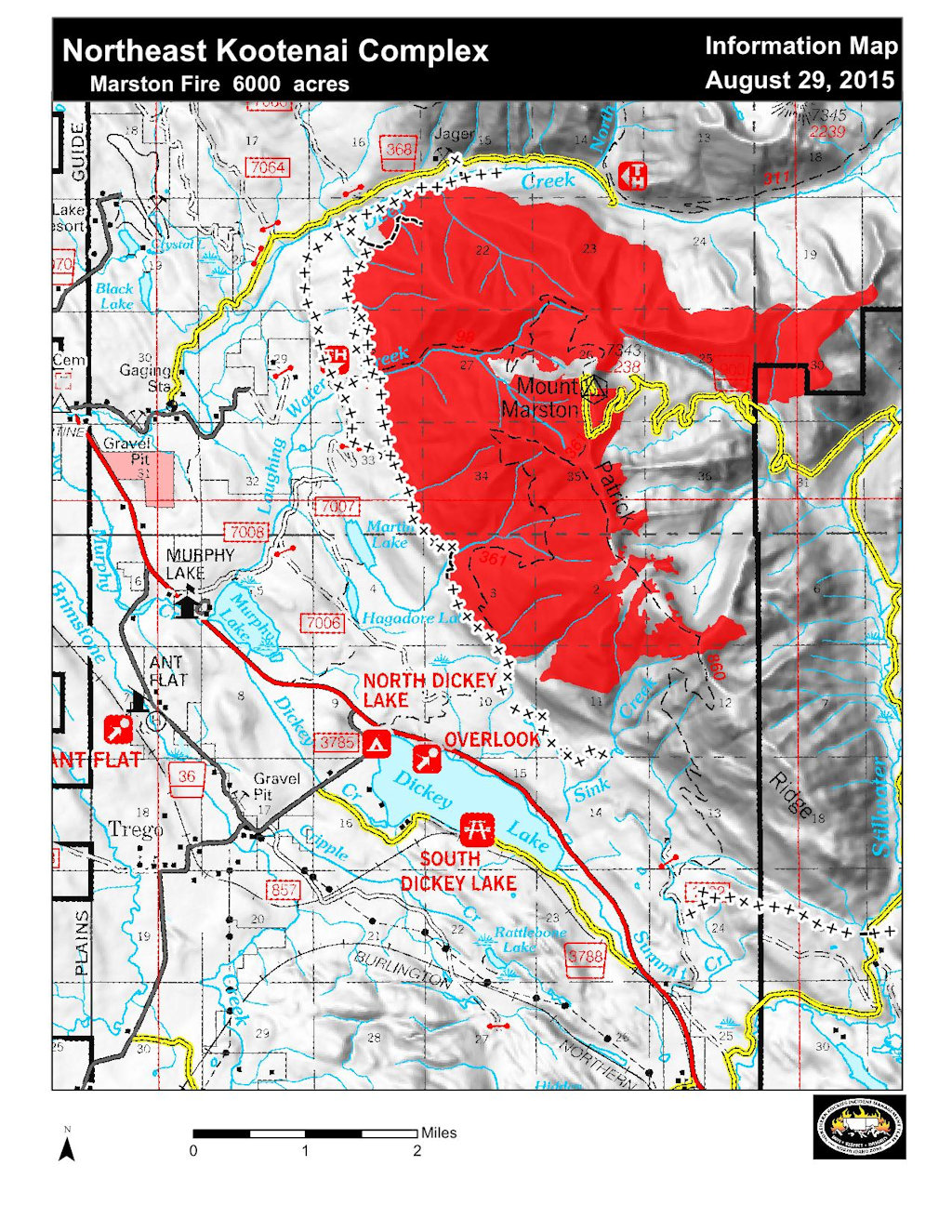
A map of the Marston and Sunday Fires of the Northeast Kootenai Complex showing their proximity to the Flathead National Forest is now posted here on InciWeb and also under the “Maps” tab. This should give residents in Polebridge and other nearby residential areas a better view of the proximity of the Marston Fire to where they live. The fire has NOT moved onto the Flathead National Forest and is approximately 20 miles away from Polebridge. Residents who are concerned about the fire are asked to contact the Northeast Kootenai Complex Fire Information Line at (406) 882-8308 and stay updated on the incident through the Northeast Kootenai Complex InciWeb site.
The big news is the Sheep Fire, which continues edging towards Essex (see map below). Essex is under a mandatory evacuation order and US Route 2 is closed in the immediate vicinity . . .
Evacuation and Highway Closure Information: Flathead County EOC, 406-758-2111, 8 a.m.-10 p.m.
Resources – Total Personnel: 332 Injuries: 1 Structures Lost: None
20-Person Hand Crews: One Type 1 and Four Type 2, 1 Wildland Fire Management Module (8), 1 Helitack Crew (10)
Air Support: Helicopters (2 Type-1 & 2 Type-3), Engines: 17 Heavy Equipment: 15
The Thompson-Divide Complex is comprised of the Sheep and Granite Fires on the Flathead National Forest and the Thompson Fire in Glacier National Park. The Sheep fire is the incident priority as it is approaching US Hwy. 2 and the BNSF railway and is threatening the community of Essex.
On August 27, Flathead County Sheriff Chuck Curry ordered a mandatory evacuation of Essex and the surrounding area because of increased activity on the Sheep Fire. For more information on the evacuation, call the Flathead County Office of Emergency Services at 406-758-2111. The American Red Cross has established an evacuation center at West Glacier Elementary School at 160 Old Bridge Rd (800-272-6668).
Highway 2 is closed between mileposts 176.8 at Schellinger and 185 at Bear Creek. BNSF trains and Amtrak are running intermittently. Call 511 or visit http://www.mdt.mt.gov/travinfo/alerts.shtml for current road status. For more information on Amtrak call 1-(800) 872-7245.
Stage II Fire Restrictions are in effect for northwestern Montana.
Closures are in effect for some trails in the vicinity of the fires for Glacier National Park and Flathead National Forest. For more info, please see the Glacier NP page http://www.nps.gov/glac/upload/8-22-15-closures-web.pdf or for Flathead NF call Hungry Horse Ranger District (406) 387-3800. The area closures around the Granite and Sheep Fires in the Great Bear Wilderness were expanded today by the Hungry Horse Ranger District. The order and map are posted at http://inciweb.nwcg.gov/incident/article/4468/28364/.
A Red Flag Warning has been issued for Saturday from noon to 8 p.m. for gusty winds and low humidity. The fires may see wind gusts in excess of 40 mph on ridge tops. Wind direction will start from the south and southeast, then come from the southwest and west with passage of a cold front. These conditions could cause active fire behavior including short crown runs and spotting up to ½ mile on all three fires in the complex. Weather conditions will be changing this weekend. A cold front is predicted to arrive late Saturday afternoon. Humidity will increase with a slight chance of showers and thunderstorms as this front passes through the area. On Sunday, temperatures will drop about 10 degrees and humidity increase. A chance for showers will remain.
Sheep Fire, Flathead National Forest
Structures At Risk: 200+ structures, BNSF has several wooden snowsheds and 1 trestle, utilities infrastructure
Fire Update: The Sheep Fire is on the Flathead National Forest and burning in very steep terrain with limited access. The fire is about 1 mile south of Essex and about 1/8 mile from the train tracks between Tank Creek and MacDonald Creek. The fire has not crossed Sheep Creek to the south. Today, fire behavior will depend on the influence of the approaching cold front and the persistence of smoke over the fire. Construction of the shaded fuel break around Essex is nearing completion. Today’s focus will be on the removal of the remaining logs and slash that was created and any cleanup of the fuel break. The objective of this fuel break is to reduce the fuel component and space the tree crowns to limit fire spread and torching. It will also provide a safe location for firefighters if it is decided to burn out fuels in advance of the fire front. Helicopters will be used to drop water on the fire to reduce fire spread as long as visibility requirements can be met. Structural protection in Essex will continue. Night shift continues to monitor fire movement and patrol the Essex area and Walton compound for any encroaching fire activity.
Granite Fire, Flathead National Forest
Approximate Size: 701 acres Containment: 0%
Fire Update: The Granite Fire is burning in very steep terrain in a mixed conifer forest. The fire is located west of Marias Pass and south of Hwy. 2. The fire started in the Great Bear Wilderness and has moved north out of the Wilderness. Yesterday, the fire moved to the west along a ridge between 2 unnamed tributaries of Granite Creek and northwest toward Patrol Ridge. A crew was flown into the Granite Cabin to put in structure protection measures, including wrapping and sprinkler placement. Crews have implemented structural protection measures on other facilities in the fire’s vicinity. Crews have established locations for fireline construction and possible shaded fuel break opportunities when sufficient crews become available for their construction. Helicopter bucket drops are being used to help check fire spread.
Thompson Fire, Glacier National Park
Approximate Size: 17,857 acres Containment: 20%
Structures At Risk: 2 historic cabins Structures Lost: None
Fire Update: The Thompson Fire is located in remote south-central backcountry of Glacier National Park about 15 miles east of the West Glacier entrance in the Thompson and Nyack drainages west of the Continental Divide. All fire personnel have been removed from this fire. It will be monitored from the air for any increased fire activity. Pumps and hose lays are in place in case a future need arises.
Most of Glacier National Park is unaffected by this wildfire complex and is available for recreational use. Limited backcountry closures are in place. For more specific visitor information, please see the website http://www.nps.gov/glac/index.htm.
The Thompson Fire has not impacted park roads. The Going-to-the-Sun Road is open.
Creeks and rivers are very low across this corner of Montana . . .
The two primary tributaries of the Flathead River have the lowest streamflows on record for late August, further reflecting the extreme drought conditions that are tormenting the region in a year being defined by smoky skies and stingy weather.
Entering the final days of August, the Middle Fork Flathead River was running at 470 cubic feet per second, a new record surpassing the previous low set in 1940, according to the National Weather Service. The median flow for this time of year is 977 cfs.
The North Fork Flathead River was running at 628 cfs, surpassing the 2001 record low. The median flow is 1,260 cfs. The streamflows are the lowest since monitoring gauges were established 75 years ago, according to Ray Nickless, NWS hydrologist.
With enough wind, the Marston Fire could make a run toward the North Fork . . .
The Marston Fire burning north of Dickey Lake near Fortine gained an estimated 800 acres Friday, pushing northeast toward Whale and Trail Creeks in the North Fork of the Flathead River.
The growing fire on the Kootenai National Forest has led to closures of roads and trails on portions of the northern Glacier View Ranger District of Flathead National Forest.
Information officer Tom Rhodes said the fire was estimated at 5,500 acres and had advanced to about 2.5 miles southwest of Whale Lake by Friday night. Rhodes said it remains about 15 miles from any residential structures near the North Fork, but critical fire conditions today could push it farther along into the drainages as strong winds are forecast to pick up this afternoon and continue into the evening.