 This spring, the North Fork Flathead River outfitter and guide permits up are up for renewal. The public comment deadline for this project is October 18!
The “Dear Interested Party” letter, quoted below, has the essential details, including instructions on submitting comments and a link to a project website containing additional reference material.
Dear Interested Party,
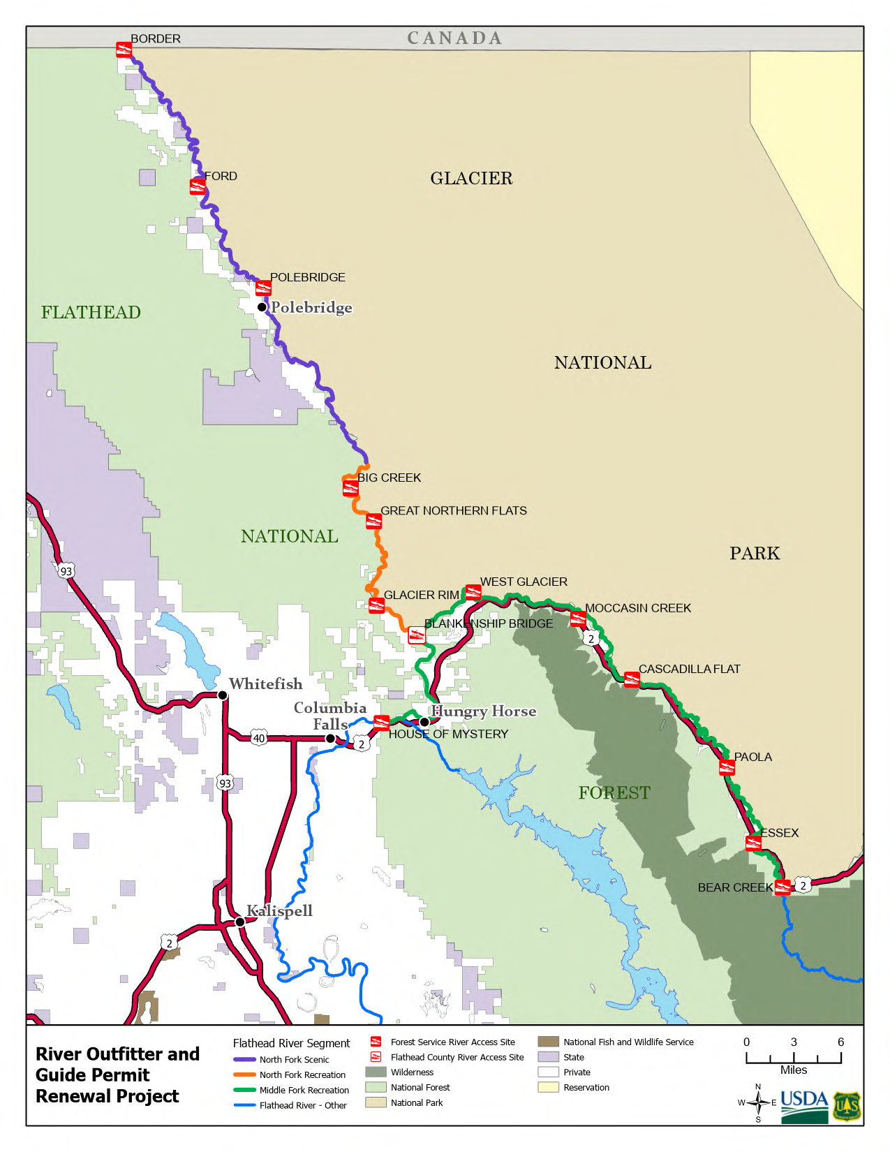
The Flathead National Forest is seeking public input on the renewal of five existing priority outfitter and guide special use permits on the non-wilderness portions of the North and Middle Forks of the Three Forks of the Flathead Wild and Scenic River. Flathead National Forest and Glacier National Park jointly manage the North and Middle Forks of the Flathead River within the project area. Flathead National Forest is the lead agency and administers the five outfitter-guide permits being considered for renewal. The project area does not include the South Fork or the Middle Fork upriver of the Bear Creek River Access Site as renewals within the Great Bear Wilderness are included in the Bob Marshall Wilderness Complex Outfitter and Guide Permit Reauthorization Project.
Permitted outfitting and guiding assures that the public has reasonable access to high-quality recreation opportunities. Given the skill and equipment needed to run these rivers safely and responsibly, many users require and prefer the services of an outfitter. Outfitters and guides on the North and Middle Forks promote and teach river and bear safety practices, resource protection (such as the proper fishing techniques), river etiquette, and the unique attributes of this Wild and Scenic River. These permits are a part of both sharing and protecting this national resource.
Additional project information is available at the project Web site: https://www.fs.usda.gov/project/?project=66916. You may submit project-specific comments, within the scope of the proposed action, by October 18, 2024. Because of the large amount of research regarding natural resource practices and methods, if you cite literature in your comments, please provide us with a complete bibliography and a copy of the referenced materials.
Please submit any comments, concerns, or suggestions regarding the implementation of this proposal electronically at: comments-northern-flathead-hungry-horse-glacier-view@usda.gov with “North and Middle Fork Flathead River Outfitter and Guide Permit Renewal Project” in the subject line. Acceptable formats include MS Word, RTF, or PDF.
Or mail comments to the following address:
Robert Davies, District Ranger
P.O. Box 190340
Hungry Horse, MT 59919
We look appreciate your interest in the management of the Three Forks of the Flathead Wild and Scenic River and look forward to hearing from you.