Category Archives: News

Reynolds Creek Fire at 2,000 acres; more evacuations and closings

Glacier National Park has their hands full with the Reynolds Creek Fire. It is now at 2,000+ acres and rates a Type I management team . . .

A rapidly spreading wildfire in Glacier National Park has now covered 2,000 acres and burned a car left by a visitor on Going-to-the-Sun Road.

Another campground is being evacuated this morning, and pre-planning is underway for the possible eventual evacuation of the community of St. Mary.

“The fire is moving quickly in heavy timber with extreme spread potential,” said Glacier Park spokeswoman Denise Germann.

Read more (with photos) . . .

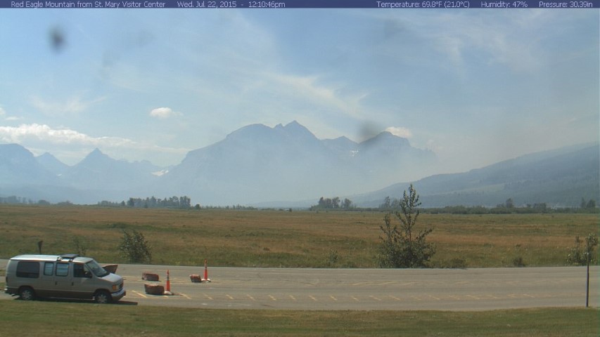
Smoke at St. Mary Entrance to GNP

Montana Governor, Feds sign sage grouse conservation deal

A little more progress on sage grouse conservation . . .

Gov. Steve Bullock signed an agreement Monday with the U.S. Department of Agriculture pledging cooperation on efforts to protect declining populations of greater sage grouse.

The agreement signed at the Capitol in Helena calls for state, federal and local officials to meet annually to discuss sage grouse conservation. It includes no new spending or regulations.

The USDA’s Natural Resources Conservation Service Chief Jason Weller said the agreement should help streamline and coordinate sage grouse conservation efforts on private land in the state. Seventy percent of sage grouse habitat in Montana is on private or state lands.

Read more . . .

Proposed Flathead Forest plan receives 20,000+ comments

The proposed Flathead National Forest Plan got lots of comments — better than 20,000. Here’s the official press release on the subject . . .

The Flathead National Forest received more than 20,000 comments on its proposal for revising its land and resource management plan (forest plan). Comments on the proposal to amend the Helena, Kootenai, Lewis and Clark, and Lolo National Forest plans to integrate the Northern Continental Divide Ecosystem Grizzly Bear Conservation Strategy were also sought during the 70 day comment period that ended May 15.

The Flathead National Forest is preparing a single environmental impact statement for both the revised forest plan and the grizzly bear amendments.

Forest Supervisor Chip Weber commented that, “The public response has been excellent; we received a lot of constructive comments that we are giving serious consideration to in order to improve our initial proposal as well as to develop some alternatives that will be able to display the range of issues expressed throughout the comment period.”

The majority of the comments received were form letters or petitions that were either identical in content or substantially similar. Approximately 370 unique comments came from individuals or commercial interests. Seven letters were from public agencies and approximately 30 letters came from non-profit organizations.

“The Flathead National Forest plan revision team has reviewed all the comments,” said Weber. “Four significant issues were identified and will be used to frame alternatives for the revised forest plan.” They are:

  1. Vegetation management, timber production, and fire;
  2. Habitat for wildlife and fish;
  3. Access and recreation; and
  4. Recommended wilderness

The planning team will be using these issues and public comments to refine the proposed action and build alternatives. Once the analysis is completed, a draft environmental impact statement will be issued. The Forest Service plans to have this document available by January 2016. Once the draft environmental impact statement is issued there will be a 90-day comment period.

The Flathead National Forest plan revision website provides additional information about the forest plan revision planning process, including links to the proposed action for the revised forest plan located at www.fs.usda.gov/goto/flathead/fpr. The amendment component of the proposed action can be found at www.fs.usda.gov/goto/flathead/gbamend. Links to a reading room containing all comments, the 2012 planning rule and, the draft NCDE Grizzly Bear Conservation Strategy can be found on these websites as well.

For further information about the project, contact Joe Krueger, Forest Planner, Flathead National Forest, 650 Wolfpack Way, Kalispell, Montana 59901, (406) 758-5243, or at flatheadplanrevision@fs.fed.us.

See also: “Forest Plan Comments Focus on Timber Production, Wildlife Habitat” (Flathead Beacon)

Red flag warning for this afternoon

The National Weather Service posted a red flag warning for this afternoon, July 22, due to gusty winds and very low humidities. It runs from 3pm to 9pm . . .

URGENT - FIRE WEATHER MESSAGE
NATIONAL WEATHER SERVICE MISSOULA MT
921 AM MDT WED JUL 22 2015

MTZ105-230300-
/O.CON.KMSO.FW.W.0003.150722T2100Z-150723T0300Z/
FLATHEAD/GLACIER PARK-
921 AM MDT WED JUL 22 2015

...RED FLAG WARNING REMAINS IN EFFECT FROM 3 PM THIS AFTERNOON TO
9 PM MDT THIS EVENING FOR GUSTY WINDS AND LOW HUMIDITIES ACROSS
THE FLATHEAD/GLACIER PARK...

A RED FLAG WARNING REMAINS IN EFFECT FROM 3 PM THIS AFTERNOON TO
9 PM MDT THIS EVENING.

* SYNOPSIS: A SURGE OF VERY DRY AIR ALONG WITH STRONG AND GUSTY
  WESTERLY WINDS WILL MOVE THROUGH NORTHWEST MONTANA THIS
  AFTERNOON AND EARLY EVENING. THIS DRY AND BREEZY WEATHER
  COUPLED WITH FUELS HAVING RETURNED TO VERY HIGH TO LOCALLY
  EXTREME CONDITIONS... NOT TO MENTION A FEW WILDFIRES ALREADY ON
  THE GROUND... A RED FLAG WARNING HAS BEEN ISSUED.

* WINDS: SUSTAINED 15-20 MPH WITH GUSTS 20-30 MPH (LOCALLY
  HIGHER) FOR SEVERAL HOURS.

* MINIMUM HUMIDITIES: 10-15% VALLEYS AND 12-18% RIDGES

* TIMING: 1500-2100

Firefighters responding to Reynolds Creek Fire in Glacier Park

Glacier Park has a growing wildfire on the east side in the St. Mary Valley. Going-to-the-Sun Road is closed, the Rising Sun Motor Inn was evacuated, as was the Rising Sun Campground. Rangers are looking for folks who might still be in the backcountry.

Here’s the official press release . . .

Firefighters and fire-fighting resources are responding to the Reynolds Creek Wildland Fire on the east side of Glacier National Park. The fire is estimated to be approximately 800-1,000 acres.

The fire is moving quickly in heavy timber with extreme spread potential.

The Going-to-the-Sun Road is closed between the St. Mary entrance on the east side and Avalanche on the west side. The road closure is in response to the fire, firefighter and visitor safety, fire response activities, and park personnel priorities. The duration of the road closure is unknown.

There is no access to any trails or backcountry areas from the Going-to-the-Sun Road at this time. Backcountry visitors are encouraged to contact the park’s backcountry office for more information.

The Rising Sun Motor Inn, operated by Glacier National Park Lodges, and the Rising Sun Campground were evacuated this evening. Park rangers and personnel are searching for backcountry hikers in the area to evacuate them and direct them to safety. The parking areas of the St. Mary Visitor Center and the Apgar Visitor Center have been established as gathering areas for park visitors that may have been separated from their group.

All interpretive programs in the St. Mary Valley are cancelled until further notice. There is a temporary flight restriction over the fire area.

A Type II Interagency Incident Command Team has been ordered and should arrive on Wednesday. Resources from Flathead National Forest, Glacier County, East Glacier, Babb, St Mary, and Cutbank, Fire Departments, Blackfeet Fire Management, Montana Department of Natural Resources, Evergreen and West Valley Fire Departments and Flathead County are assisting Glacier National Park.

A fire information phone line has been established at 406-732-7791.

The fire was first reported at approximately 3:45 p.m. on Tuesday and was located near Grizzly Point, approximately six miles east of Logan Pass. Park dispatch received numerous reports of the fire from shuttle bus drivers, Glacier Boat Company employees, park employees and visitors

Montana FWP wildlife biologist Gael Bissell retires

The Daily Inter Lake has a nice profile of Gael Bissel, a well-regarded wildlife biologist who recently retired from Montana Fish, Wildlife and Parks . . .

Chances are you don’t know her name, but if you’ve ever hunted state lands along the Thompson River Corridor, reeled in a fish from the streams of the Swan River State Forest or simply savored the natural beauty of the Bull River Valley, you ought to thank Gael Bissell.

Originally from Wilmington, Delaware, Bissell officially retired earlier this month after a 31-year career as a wildlife biologist with Montana Fish, Wildlife and Parks, having had a hand in nearly a quarter of a million acres of wildlife habitat conservation.

Working behind the scenes with myriad public and private partners, she helped secure a combination of land purchases, donations and easements throughout Northwest Montana worth approximately $120 million.

Read more (paywall) . . .

NFPA Annual Meeting to be held on Saturday, July 25

On Saturday, July 25, the annual meeting of the North Fork Preservation Association will be held at Sondreson Community Hall on the North Fork Road at Whale Creek.

At 7:30 pm Vernon Finley, Chairman of the Confederated Salish and Kootenai Tribe and Keeper of the Kootenai Language, will speak on topics relating to Kootenai history. He is well known for being an engaging speaker.

The 7:30 pm program is preceded by a potluck dinner starting at 5pm and election of officers at 6:45 pm. Everyone is invited.

For more information phone (406) 888-5084

Comments encouraged on Inside North Fork Road

As mentioned here earlier, Glacier Park is soliciting public comment on their plans for the Inside North Fork Road. The comment period ends August 3. Here’s the meat of the official press release on the subject . . .

Glacier National Park is preparing an environmental assessment for the management of the inside North Fork Road and encouraging public comment by August 3. Public comments will help identify issues and alternatives to be considered and evaluated in the planning process.

The inside North Fork Road is located within the park. It is a seasonal gravel road approximately 40 miles in length. It begins near the south end of Lake McDonald continuing to Kintla Lake near the Canadian border. The road was constructed in 1901 and is listed on the National Register of Historic Places.

Currently, the road is open between the Fish Creek Campground and Camas Creek on the south end of the road, and between Polebridge and the Logging Creek Ranger Station on the north end of the road. Hikers and bikers may utilize the entirety of the inside North Fork Road. The middle section of the road is not open to motorized use due to road damage.

Since 2006 annual flooding has caused significant and recurring damage to the inside North Fork Road, particularly near the Anaconda Creek and Logging Creek areas. Another area of the road, near the North Fork of the Flathead River between Quartz Lake and Logging Creek, known as Lover’s Leap, is also an area of concern. The river is beginning to undercut this section of the road due to sloughing of the riverbank. Culvert additions and replacements along much of the road and new road base are needed in several locations.

In response, the park has brought in materials to mend damaged areas over the past several years. These fixes have been short-lived and resulted in deposition of road base and sediment into waterways, raising concern for fisheries and the health of riparian communities. In 2014, the park contracted an engineering firm to analyze options for road repairs at Anaconda and Logging Creeks, and Lover’s Leap. Cost estimates for these three repairs ranged from $682,000 to $735,000.

The park’s general management plan calls for preservation of the area’s wild character, with provision of only rustic visitor facilities. The road provides access to four primitive auto campgrounds and several trailheads. These few developments are surrounded by recommended wilderness.

Bull trout, a federally listed threatened species, and westslope cutthroat trout, a Montana State listed species of concern, utilize riparian habitat on and near the North Fork of the Flathead River, including federally designated critical habitat for bull trout. Road failures near Anaconda Bridge and Logging Creek are causing localized stream habitat degradation, with the potential to adversely impact bull trout critical habitat.

Given the repairs needed, associated costs, and ongoing maintenance requirements and resource concerns, the park is considering the overall future of the inside North Fork Road. An environmental assessment is being prepared for the management of the road. Objectives include developing a sustainable approach for maintenance and repair of the road, improving natural stream function in riparian areas, reducing adverse impacts on fisheries, and continuing to provide recreation opportunities in the North Fork area of the park.

A scoping brochure is available online, and comments and concerns regarding the project should be submitted online at parkplanning.nps.gov/InsideNorthForkRoad. Comments and concerns can also be mailed to Superintendent, Glacier National Park, Attn: inside North Fork Road, PO Box 128, West Glacier, MT 59936. Comments should be submitted by August 3.

Beavers make things better for amphibians

Here’s some interesting research on the relationship between beaver activity and amphibian populations . . .

Beavers in Glacier National Park modify wetlands in a way that makes them better suited for the health of the park’s amphibian population, according to a study published this month.

The paper, published in the journal Biological Conservation, suggests that even though most amphibian populations are shrinking, the influence of beavers on their habitats can decrease the severity of the decline. While the influence isn’t enough to reverse the trend – many amphibians are falling prey to a fungus unrelated to the absence of beavers – they can mitigate it.

In 2002, Blake R. Hossack and six other researchers began studying the distribution of amphibians in Glacier, Yellowstone, Grand Teton, and Rocky Mountain national parks. The project was a joint monitoring program with the U.S. Geological Survey and the National Park Service.

Read more . . .