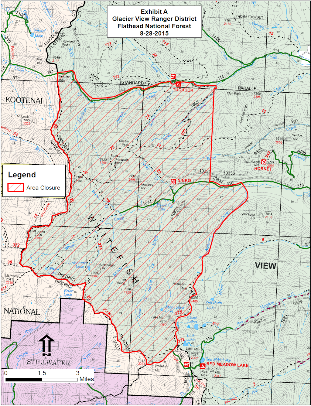
It’s official. The Forest Service is closing an area of the Flathead National Forest in the North Fork as a precautionary measure in case the Marston Blaze comes over the Whitefish Divide. This is not terribly likely, but the fire weather is a big concern over the next couple of days.
As near as I can tell from the map, only two roads are affected. Trail Creek Road is now closed just west of the Tuchuck Campground. Whale Creek Road is closed about four miles past the turnoff for the Hornet Lookout. At present, Red meadow Road is unaffected.
Here is the official morning report on the fires in the Thompson-Divide Complex, including the Thompson, Sheep, and Granite blazes.
The biggest nuisance right now is the Sheep Fire. Its growth has triggered a mandatory evacuation notice for Essex and the closure (again) of US Route 2 . . .
Evacuation and Highway Closure Information: Flathead County EOC, 406-758-2111, 8 a.m.-10 p.m.
Resources – Total Personnel: 335 Injuries: 1 Structures Lost: None
20-Person Hand Crews: 1 Type 1 and Type 2, 1 Wildland Fire Management Module (8), 1 Helitack Crew (10)
Air Support: Helicopters (1 Type-1 & 2 Type-3), Engines: 16 Heavy Equipment: 4
The Thompson-Divide Complex is comprised of the Sheep and Granite Fires on the Flathead National Forest and the Thompson Fire in Glacier National Park. The Sheep fire is the incident priority as it is approaching US Hwy. 2 and the BNSF railway and is threatening the community of Essex.
On August 27 Flathead County Sheriff Chuck Curry ordered a mandatory evacuation of Essex and the surrounding area because of increased activity on the Sheep Fire. Sheriff’s Deputies have contacted residents who are affected by this order. For more information on the evacuation, call the Flathead County Office of Emergency Services at 406-758-2111. The American Red Cross has established an evacuation center at West Glacier Elementary School
Highway 2 is closed between mileposts 176.8 and 185 around Essex. BNSF trains and Amtrak are running intermittently. Call 511 or visit http://www.mdt.mt.gov/travinfo/alerts.shtml for current road status. For more information on Amtrak call 1-(800) 872-7245.
Stage II Fire Restrictions are in effect for northwestern Montana.
Closures are in effect for some trails in the vicinity of the fires for Glacier National Park and Flathead National Forest. For more info, please see the Glacier NP page http://www.nps.gov/glac/index.htm or for Flathead NF call Hungry Horse Ranger District (406) 387-3800.
A Red Flag Warning has been issued for this afternoon for gusty winds and low relative humidity. These conditions are expected to cause active fire behavior including short crown runs and short range spotting on all three fires in the complex. Weather conditions will be changing going into the weekend. A cold front is approaching on Sunday with maximum temperatures expected to drop 10-15 degrees. In advance of this front, winds are expected to increase Friday and Saturday. Humidity will increase with a slight chance of showers and thunderstorms with this advancing front. Winds will be from the southwest increasing to 15-20 mph with gusts of 25-35 on the ridges possible on Saturday.
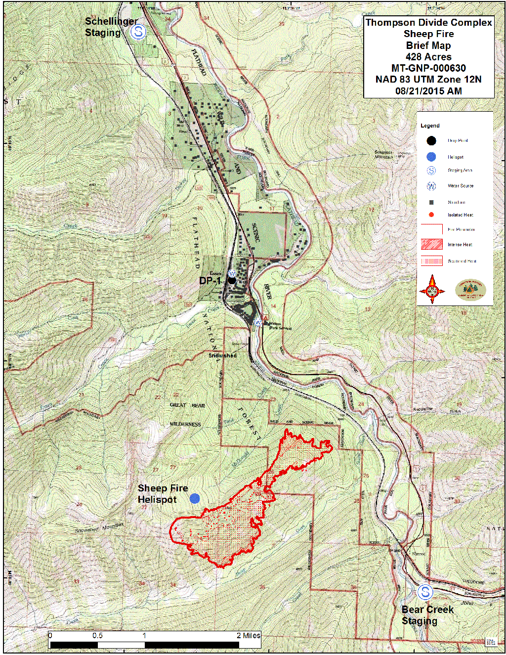
Fire Update: The Sheep Fire is on the Flathead National Forest and burning in very steep terrain with limited access. The fire is about 2 miles south of Essex and less than 1/4 mile from the train tracks between Tank Creek and Sheep Creek. The fire crossed MacDonald Creek and moved down slope yesterday on the ridge south of Tank Creek. It also moved downslope to portions of Sheep Creek, but has not crossed that drainage. It also made an advance west to a ridge coming from Snowshed Mountain. Construction of a shaded fuel break using heavy equipment on the west-side of the BNSF railroad tracks from Sheep Creek to Dickey Creek drainages started Aug. 26. This will continue today between Dickey and MacDonald Creeks as long as conditions permit. The objective of this fuel break is to reduce the fuel component and space the tree crowns to limit fire spread and torching. It will also provide a safe location for firefighters if it is decided to burn out fuels in advance of the fire front. A BNSF work train is being used to move crews and equipment. Helicopters continue to do water drops to check fire spread when visibility allows. Structural protection in Essex will continue. A night shift continues to monitor fire movement and patrol the Essex area and Walton compound for any encroaching fire activity.
Fire Update: The Granite Fire is burning in very steep terrain in a mixed conifer forest. The fire is located west of Marias Pass and south of Hwy. 2. The fire started in the Great Bear Wilderness and has moved north out of the Wilderness. Yesterday, the fire moved to the west along a ridge between 2 unnamed tributaries of Granite Creek and northwest toward Patrol Ridge. Crews have implemented structural protection measures on several backcountry cabins, trailhead structures, a wooden road bridge and a radio repeater. Crews have established locations for fireline construction and possible shaded fuel break opportunities when sufficient crews become available for their construction. Helicopter bucket drops are being used to help check fire spread.
Structures At Risk: 2 historic cabins Structures Lost: None
Fire Update: The Thompson Fire is located in remote south-central backcountry of Glacier National Park about 15 miles east of the West Glacier entrance in the Thompson and Nyack drainages west of the Continental Divide. Increased fire activity was seen within the fire perimeter south of Tinkham Mountain today. Firefighters in the Nyack Creek drainage finished burnout and mop up operations in the northwest corner (Division A) of the fire and were flown out yesterday. Pumps and hose lay are in place in case a future need arises and the fire will be monitored by air.
Most of Glacier National Park is unaffected by this wildfire complex and is available for recreational use. Limited backcountry closures are in place. For more specific visitor information, please see the website http://www.nps.gov/glac/index.htm.
The Thompson Fire has not impacted park roads. The Going-to-the-Sun Road is open.
Note this item from the “Special Messages/Closures” section: “A new Area Closure for the Hungry Horse Ranger District, Flathead National Forest is being developed in anticipation of the Marston Fire moving into the area and will be posted on InciWeb when finalized today.” It now appears that Whale Creek Road will, in fact, be closed.
Information Officers: Katie Knotek, Tom Rhode & Meg Nemitz Fire Information Line: (406) 882-8308 Office hours: 8:00 a.m. to 8:00 p.m. Email:northeastkootenaicomplex@gmail.com
INCIDENT: Northeast Kootenai Complex (includes Barnaby, Marston, and Sunday Fires) AGENCY JURISDICTION: USDA Forest Service, Kootenai & Flathead National Forests; Montana DNRC, Libby and Stillwater Units. INCIDENT COMMANDER: Shawn Pearson, Northern Rockies Type II Incident Management Team (IMT). The Incident Command Post (ICP) is located at the Murphy Lake Ranger Station.
WEATHER & FIRE BEHAVIOR: A Red Flag Warning is issued for today due to a break in the valley inversion and smoke cover, continued hot (80s), dry (relative humidity 16-21%) conditions and wind gusts out of the southwest up to 20 mph in the late afternoon. Fire behavior will be active today with short crown runs.
MARSTON FIRE:
The Marston Fire is estimated at 4,790 acres with 5% containment. The fire increased in size yesterday, but an infrared flight was not available to provide accurate mapping of the current fire perimeter. Fire growth was primarily to the east towards the Flathead National Forest and the Stillwater State Forest. On the north end of the fire, Hotshot crews worked on checking fire spread as it backed downhill, and feller bunchers continued to work on indirect line construction along Deep Creek. These operations will continue today as conditions permit. On the fire’s west side, crews will continue to blacken and secure fireline to the south and check fire spread as it moves downhill. Heavy equipment work constructing fuel breaks south of the fire and east towards the Stillwater State Forest will continue.
SUNDAY FIRE:
The Sunday Fire located about four miles southeast of Stryker, MT, is 60 acres with 100% containment. A Palm IR (Infrared) unit will be used today to check for any remaining hot spots on the fireline. There is no longer a threat of evacuation for local residents in the vicinity of the Sunday Fire and the Population Protection Plan has been removed from Inciweb.
BARNABY FIRE:
The Barnaby Fire is located about four miles northeast of Eureka in steep, rugged terrain. The fire is being monitored from the air with bucket drops from helicopters when possible. Strong valley inversions and smoke cover have prevented aerial observation and bucket drops on the fire for the last several days. The fire remains 50 acres with 0% containment.
PERSONNEL AND RESOURCES: 348 personnel including 3 Type -1 crews, 5 Type – 2 crews, 12 engines,
3 helicopters (2 Type – 1 Chinooks, 1 Type – 2), 6 dozers, 9 water tenders, and 4 skidgines.
SPECIAL MESSAGES/CLOSURES: There is an area closure for both the Martson and Barnaby Fires. The Marston Fire Area Closure includes closure of Murphy Lake for the safety of both firefighting equipment and the public, as helicopters dip out of Murphy Lake for water drops on the Martson Fire. See Inciweb for maps and explanations of these closures. A new Area Closure for the Hungry Horse Ranger District, Flathead National Forest is being developed in anticipation of the Marston Fire moving into the area and will be posted on InciWeb when finalized today.
The Incident Management Team will have a booth at the Lincoln County Fair this weekend. A Community Meeting will be held Sunday evening, August 30, at 7:00 p.m. at the Trego Civic Center.
For more information on the fires, visit: http://inciweb.nwcg.gov/; Select “Northeast Kootenai Complex”
The Spotted Bear Ranger District closed its portion of the Bob Marshall Wilderness due to the fire danger . . .
As fires bloom, the options to recreate in the Bob Marshall Wilderness are rapidly diminishing. The Spotted Bear Ranger District will shut down the entire wilderness portion of the district because of fires and fire danger beginning Friday morning, fire information officer Al Koss said. That includes lands in both the Bob Marshall and the Great Bear Wilderness.
The non-wilderness portion remains open, though the Spotted Bear Campground is closed. Koss said wilderness rangers are giving who are already in the backcountry a few days to get out of the area.
The decision came as multiple fires burn in the district. One new fire, detected yesterday, is near Lena Lake in the wilderness. That fire is now 40 acres in size. That forced the closure of the Holland Lake trailhead. The Meadow Creek Trailhead is also closed due to the fires.
Flathead County Sheriff Chuck Curry ordered a mandatory, but precautionary, evacuation for Essex today at 2:40 p.m. The Sheep Fire is still on the ridge above the mountain town east of Columbia Falls. The fire is growing due to winds and temperatures in the 80s today, public information officer Sonja Hartman said.
They want to get people out of the town so firefighters can be stationed in the town, Hartman said. They decided it would be easiest to get people out earlier rather than later.
The Forest Service is going to close Whale Creek Road due to the run the Marston Fire made. Apparently, they are worried it might cross the Whitefish Divide.
Today and tomorrow are going to be bad fire weather days. At 10:33 am a Red Flag warning was issued for tomorrow (Saturday, August 29) with 45mph winds and 10% relative humidity.
Here is the official morning report on the wildfires in the Northeast Kootenai Complex, including the Barnaby, Marston, Sunday and Weigel blazes.
Although the Marston Fire is a potential threat if things go seriously awry, the only impact these fires presently have on the North Fork is the closure of the Trail Creek Road at the Kootenai Forest boundary . . .
AGENCYJURISDICTION: USDA Forest Service, Kootenai & Flathead National Forests; Montana DNRC, Libby and Stillwater Units.
INCIDENTCOMMANDER: Shawn Pearson, Northern Rockies Type II Incident Management Team (IMT). The Incident Command Post (ICP) is located at the Murphy Lake Ranger Station.
WEATHER & FIRE BEHAVIOR: Warm, sunny and dry day with light winds will increase fire activity in the afternoon today. A warm and dry trend will continue through the week; a Fire Weather Watch has been issued for Monday.
MARSTON FIRE:
The Marston Fire is estimated at 3,200 acres with 5% contained and is located about three miles southeast of Fortine, MT. Dozer and hand line have been completed along the fire’s western edge and north to Deep Creek drainage. Crews are now working on opening roads for access to the fire’s northeast side near the mouth of Deep Creek. Dozer line has been completed from Laughing Water Creek to Sink Creek and crews will work on laying hose to supply water to the line. Indirect line is being scouted for the east side of the fire adjacent to the Stillwater State Forest. Helicopters will drop water on the southeast and northwest corners of the fire again. The fire may become more active throughout the week with warmer temps and low humidity, residents are asked to stay informed of changing fire conditions. The population protection plan is still in place for residents living near Laughing Water, Deep and Grave Creeks. This determines when evacuations would take place in the vicinity of the Marston Fire. A copy of the plan can be found on the Northeast Kootenai Complex Inciweb page (link listed below). No evacuations are currently in effect.
SUNDAY FIRE:
The Sunday Fire located about four miles southeast of Stryker, MT, is at 60 acres with 90% contained. Fireline has been constructed around the fire perimeter, and crews are working on mopping up and cooling hot spots within the fire’s perimeter. The population protection plan is still in place and determines when evacuations would take place in the vicinity of the Sunday Fire. A copy this plan can be found on the Northeast Kootenai Complex Inciweb page (link listed below). No evacuations are currently in effect.
BARNABY FIRE:
The fire is located about four miles northeast of Eureka in very steep and rugged terrain. Fire activity has been minimal in the last two days with the cooler weather and has stayed at about 40 acres with 0% containment. A Type 1 helicopter will be available to drop water as needed.
PERSONNELAND RESOURCES: 320 personnel including 1 Type 1 crew, 5 Type 2 crews, 16 engines,
Helicopters: 2 Type 1, 1 Type 2, and 1 Type 3, 6 dozers, 8 water tenders, 4 skidgines, and .
SPECIALMESSAGES/CLOSURES: There is an area closure for the Barnaby Fire as well as for the Marston Fire. See Inciweb for maps and explanations of these closures. There will be a public meeting in Trego at the Civic Center on Monday August 24th at 7:00PM.
Residents in Lincoln County interested in signing up for reverse 911 or “Code Red” can visit this website for further information: http://www.lincolncountymt.us/
Formoreinformation on the fires, visit: http://inciweb.nwcg.gov/; Select “Northeast Kootenai Complex”
The feds have decided to make a decision about energy leases in the Badger-Two Medicine region. By November 30, they will either commence to cancel the leases …or not.
This would be funny if the consequences weren’t so serious. Just read the darn article while I go bang my head on my desk . . .
Public land managers have submitted a court-ordered schedule framing the steps they’ll take to either lift a suspension of oil and gas drilling on a prized and culturally sacred landscape adjacent to Glacier National Park or cancel the energy leases outright.
In setting the schedule, federal land managers for the first time are considering the dissolution of energy leases in the Badger-Two Medicine area as an option to settle a dispute over whether they were granted illegally, as leaders of the Blackfeet Nation contend. The Badger-Two Medicine is home to the Blackfeet creation story and is at the center of a hard-fought legal battle, with the lease-holder calling for the drilling suspension to be lifted on one side and a vast coalition of tribes, conservation groups and Montana politicians urging permanent protection on the other.
The timeline to resolve the decades-old suspension of an energy lease in the Badger-Two Medicine was drafted after a federal judge ordered the U.S. Department of Justice, the Bureau of Land Management and the U.S. Forest Service to draft a schedule for the agencies to complete their review.
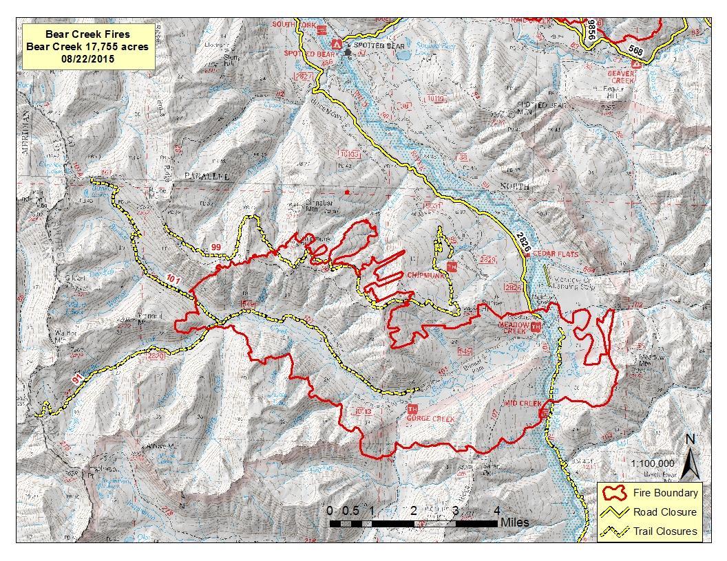
The Spotted Bear Ranger District has their hands full. Last Thursday afternoon, the Bear Creek Fire blew up from 465 acres to 17, 755 acres over a few hours. The Trail Fire better than doubled in size from 3,500 to 8,463 acres.
Here is the official morning report on the fires in the Thompson-Divide Complex, including the Thompson, Sheep, Granite and Spruce blazes. The items of immediate interest are the the reopening of U.S. Highway 2 between West Glacier and East Glacier and the resumption of rail traffic through that corridor . . .
Fire Information: (406) 387-4854/ (406) 314-1669, 8 a.m.-8 p.m.
Resources – Total Personnel: 268 Injuries: 1 Structures Lost: None
Hand Crews: 5 20-person, 1 Wildland Fire Management Modules, 1 Helitack Crew (10), Smokejumpers (3)
Air Support: Helicopters (2 Type-1 & 2 Type-3), Engines: 13
The Thompson-Divide Complex is comprised of the Sheep, Granite and Spruce Fires on the Flathead National Forest and the Thompson Fire in Glacier National Park.
Highway 2 is reopened, with pilot cars escorting traffic in both directions to ensure safe traffic flow through the fire area. Pilot cars will run 24 hours a day, but the highway could be closed due to changing fire conditions. Expect delays of 10-15 minutes. Call 511 or visit http://www.mdt.mt.gov/travinfo/alerts.shtml for current road status.
There will be a public meeting at the Izaak Walton Inn tonight, Sunday, August 23rd at 8:00 pm.
The BNSF and Amtrak trains have been running. For more information on Amtrak call 1-(800) 872-7245.
Stage II Fire Restrictions are in effect for Northwest Montana.
‘Set’ stage alert is still in effect for residents and businesses in the vicinity of Essex for possible evacuation.
Today weather conditions will continue with a warming and drying trend that will bring higher temperatures of 75 to 80 degrees in the valleys. A mild inversion is expected to break early afternoon. Fire activity is expected to increase to moderate, with more ventilation.
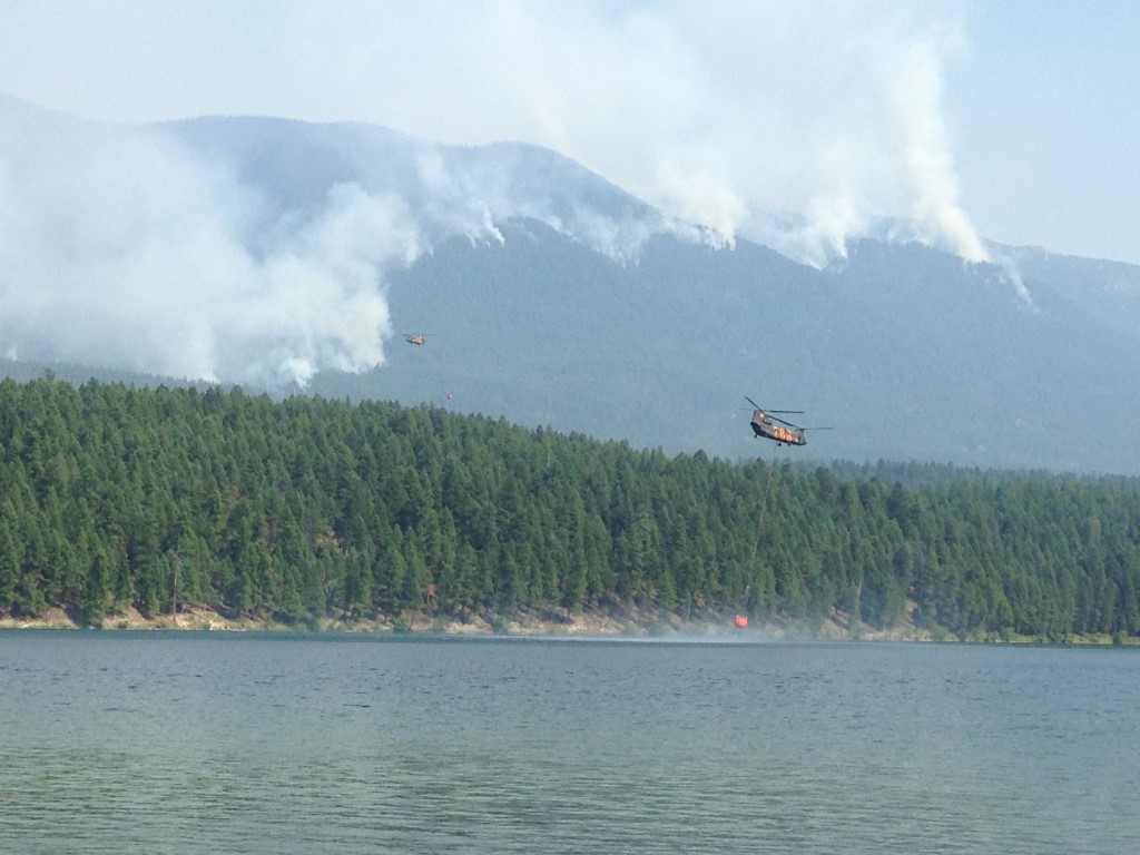
Air operations will continue today with two Type 1 helicopters, a Sky Crane and Chinook. A mobile fire retardant base is being used for helicopter bucket drops.
Visit http://svc.mt.gov/deq/todaysair/ for air quality info. Closures are in effect for some trails in the vicinity of the fires for Glacier National Park and Flathead National Forest. For more info, please see Glacier NP page http://www.nps.gov/glac/index.htm or for Flathead NF call Hungry Horse Ranger District (406) 387-3800.
Fire Update: The Sheep Fire is about 1 mile south of Essex in the Great Bear Wilderness of Flathead National Forest. It is burning in very steep, difficult terrain with limited access. Increased fire activity is expected today with warmer, drier conditions. Three crews may start building fire line today if conditions permit on the NE flank of the fire on the steep face across from the Goat Lick and to the north. Helicopters will support line building efforts as needed. Goals are to keep this fire from going north towards Essex and moving into the transportation corridor along the Middle Fork of the Flathead River.
Residents in the Highway 2 corridor around Essex remain in the ‘Set’ Stage of the Ready, Set, Go evacuation strategy. Residents of Essex and the surrounding area have been advised that they may be evacuated if the Sheep Fire becomes an imminent threat. People should have critical property and needs loaded into their vehicles in preparation for evacuation. They should have an evacuation plan in place and make sure everyone knows the plan. Visit http://www.wildlandfirersg.org/ for more information. The night shift continues to monitor fire movement.
Fire Update: The Granite Fire is west of Marias Pass and south of Hwy. 2 in the Great Bear Wilderness. It is burning in very steep terrain in a mixed conifer forest below a ridge. Crews have implemented structural protection measures on several backcountry cabins, trailhead structures, a wooden road bridge, and a radio repeater. Three engines will be on this fire today. The Granite Creek Trail (#156) is closed. Yesterday the fire was most active to the north and west.
Approximate Size: 3 acres Containment: 100% Fire Update: The Spruce Fire was added to the complex Aug. 19. The Spruce Fire is about 5 miles south of U.S. 2 at Bear Creek in the Great Bear Wilderness. Crews worked on establishing control lines yesterday and this small fire is now at 100% containment. Today crews will finish up monitoring and checking for any remaining hot spots. The fire will go into monitoring status.
Structures At Risk: 2 historic cabins Structures Lost: None
Fire Update: The Thompson Fire is located in a remote south-central backcountry area of Glacier National Park about 15 miles east of the West Glacier entrance in the Thompson and Nyack drainage and west of the Continental Divide.
Crews achieved some containment yesterday and are close to finishing mop-up of all edges of the fire. The fire remains west of the Divide and poses no threat to communities around East Glacier and St. Mary. Crews are shifting focus to rehabbing their camp and leaving this fire. The fire will go into monitoring status.
Most of Glacier National Park is unaffected by this wildfire complex and is available for recreational use. Limited backcountry closures are in place. For more specific visitor information, please see the website http://www.nps.gov/glac/index.htm.
The Thompson Fire has not impacted any park roads. The Going-to-the-Sun Road is open.