Category Archives: Flood Information

One-stop flood information for Northern Rockies

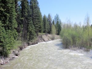
Whale Creek near flood stage, May 16, 2018 - by William K. Walker
Whale Creek near flood stage, May 16, 2018 – by William K. Walker

This is handy. So handy, in fact, that we’ve added it to the site’s “Flood Information” page.

The National Weather Service office in Missoula constructed a sort of one-stop information page for all Northern Rockies flood-related information. Here’s the official write-up . . .

This past winter the Northern Rockies experienced significant snowfall with many mountain observations hitting record values. This snow has been steadily melting this past May and will continue into June producing flooding conditions throughout the Northern Rockies. This web page was developed to pull all hydrology products into one location. Click on the tabs… to observe the river and stream gauges within each county that is serviced by the National Weather Service in Missoula, Montana.

Recommended! Check it out.

Warming weather brings flooding concerns

Expected increased runoff from near-record snowpack is triggering warnings about rising river levels.

Reminder: The Flood Information page has links to flood-related information, including river levels, snowpack data and forecasts. . . .

Warm weather could cause area rivers to reach flood stage this week, due in part to a deep mountain snowpack. The National Weather Service in Missoula issued a hydrologic outlook on May 12 for much of western Montana in advance of the rising temperatures.

According to NWS-Missoula meteorologist Trent Smith, the snowpack in the Flathead Basin is 148 percent of normal for this time of year and if it melts rapidly that could cause problems for communities downstream. The snowpack is even larger in other areas.

“There is still plenty of moisture in the mountains and so those small rivers and streams will be running high this week,” Smith said.

Read more . . .

Hefty snowpack to raise streams across Northern Rockies

Looks like we’re due for above average runoff over the next few months . . .

A hefty mountain snowpack in the Northern Rockies has driven down the summer wildfire potential and bumped up prospects that farmers in most of Montana and Wyoming won’t go dry.

As for flooding, government forecasters say the coming weeks will make all the difference.

A relatively even warm-up would keep streams and rivers in check. Too much warm weather and flooding could threaten downstream communities.

Read more . . .

Flood watch in effect through Thursday

UPDATED

All this rain has caused the National Weather Service to post a flood watch through Thursday. They are looking for sharp rises in river levels, specifically for the North Fork and Middle Fork. At this point, the river level forecast data for Flathead County shows expected heights around flood level for the North Fork at the Canadian border during Wednesday-Thursday. (However, the actual river level readings are running well below the forecast.)

Here’s the official flood watch language:

Statement as of 9:45 AM MDT on June 06, 2012

… Flood Watch remains in effect through Thursday morning…

The Flood Watch continues for

* a portion of northwest Montana… including the following counties… Flathead and lake.

* Through Thursday morning

* excessive rainfall resulting from a strong storm system will impact northwest Montana… creating the potential for flooding.

* The Flathead river… including the North Fork and Middle Fork branches… could see dramatic rises in water levels that could cause them to reach flood stage in the next several days. Smaller streams are also at risk for higher flows.

Some Northwest Montana rivers and streams could approach flood stage by midweek

The current unseasonably warm weather will get snowpack runoff moving at a faster pace. Some Northwest Montana rivers and streams could approach flood stage by midweek. Locally, the North Fork Flathead River is forecast to get within half a foot of flood stage at the Canadian border by Wednesday, lasting through the end of the week. See the Flood Information page for links to further information.

Warm days; rising waters

The warm weather triggered a rise in river levels. It doesn’t look like much excitement in the Flathead Valley, though . . .

The National Weather Service is projecting Northwest Montana rivers and streams to rise over the next few days with some expected to approach or exceed flood stage.

The rising waters are due to recent warm weather and rain that is expected Wednesday night, continuing through Thursday. Along the Montana-Idaho border, as much as an inch is expected. About a half inch is expected in areas farther east.

Continue reading . . .

Local rivers still running high

The National Weather Service is still concerned about local flooding potential. From the Daily Inter Lake . . .

While the threat of flooding has waned on most Western Montana rivers, that is not the case for the Flathead and Swan rivers, which are expected to remain near or over flood stage possibly for the next two weeks.

The Flathead River at Columbia Falls rose nearly three feet Wednesday and Thursday to flows just shy of the river’s 14-foot flood stage. While the Flathead River has gone up and down over the last few weeks, it is expected to remain high with no significant declines over the next week at least.

“The Flathead River is going to be a big concern over the next week or maybe the next two weeks,” said Dan Zumpfe, a meteorologist with the National Weather Service in Missoula.

Continue reading . . .

Cool weather might keep main rivers below flood stage

Looks like flooding concerns are easing off a bit. Here’s an early morning post to the Daily Inter Lake . . .

A couple of warm days and a few heavy rainstorms haven’t resulted in many changes to area river levels, Flathead County Office of Emergency Services Director Scott Sampey said Thursday.

But, that could change, he said.

Forecasts call for the main Flathead River and the Middle Fork at West Glacier to reach action stage today or Saturday.

Continue reading . . .

Rain, warm weather to bring new flooding to parts of western Montana

Some of the discussion below doesn’t match the current North Fork flood gauge forecasts, but it behooves everyone to keep an eye on the river for the next two or three days. Also, the flood watch released yesterday is still in effect.

From the Missoulian . . .

Warm weather and a deep mountain snowpack will continue to cause concern for western Montana in coming days.

Flooding is expected across the region, starting late Thursday for many smaller tributaries and creeks. Flooding along major rivers is expected late Friday and early Saturday, said Dan Zumpfe, meteorologist with the National Weather Service in Missoula…

As for the Flathead, snowmelt from Canada will push the river to flood stage, likely causing problems for communities such as Polebridge and Columbia Falls.

“All (of the rivers) will be going at or above flood stage in the late Friday/early Saturday time frame,” Zumpfe said. “The good thing about this warmup is that it is short lived.”

Continue reading . . .

Flood watch issued for all stems of the Flathead river from Friday through Sunday morning

The National Weather service has issued a flood watch for the upper end of the Flathead drainage. Currently, they are forecasting a brief period of flooding for the North Fork at the Canadian border starting late Thursday/early Friday, but not for Polebridge. Here’s the official wording . . .

… Flood Watch in effect for all stems of the Flathead river from Friday morning through Sunday morning…

The National Weather Service in Missoula has issued a

* Flood Watch for all stems of the Flathead river in northwest Montana… including the following County… Flathead.

* From Friday morning through Sunday morning

* warm temperatures this week have enhanced melting of the record snow pack throughout the Flathead river basin. Steady rises on all stems of the Flathead river are forecast and flood stages may be reached as early as Friday.

* Small streams that feed the Flathead may also rise and approach flood levels this week and through the weekend.

Precautionary/preparedness actions…

A Flood Watch means there is a potential for flooding based on current forecasts.

You should monitor later forecasts and be alert for possible flood warnings. Those living in areas prone to flooding should be prepared to take action should flooding develop.