Tag Archives: flooding

One-stop flood information for Northern Rockies

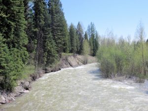
Whale Creek near flood stage, May 16, 2018 - by William K. Walker
Whale Creek near flood stage, May 16, 2018 – by William K. Walker

This is handy. So handy, in fact, that we’ve added it to the site’s “Flood Information” page.

The National Weather Service office in Missoula constructed a sort of one-stop information page for all Northern Rockies flood-related information. Here’s the official write-up . . .

This past winter the Northern Rockies experienced significant snowfall with many mountain observations hitting record values. This snow has been steadily melting this past May and will continue into June producing flooding conditions throughout the Northern Rockies. This web page was developed to pull all hydrology products into one location. Click on the tabs… to observe the river and stream gauges within each county that is serviced by the National Weather Service in Missoula, Montana.

Recommended! Check it out.

Heavy snowpack may bring flooding but reduce fire intensity

This is a little like discussing the World Series after the first few games, but forecasters are hoping for reduced fire danger to go with the above average snowpack and flooding danger this year . . .

A wet Montana doesn’t burn very well.

That’s the mixed message from the Montana Governor’s Drought and Water Supply Committee forecast presented Wednesday in Missoula. A much-above-average snowpack in the mountains may produce flooding in many river drainages across western Montana. But the moisture should also keep the 2014 fire season below average in intensity.

“Usually the long-range forecast for July and August in the Intermountain West has a big drought bull’s-eye over the area,” said Northern Rockies Predictive Services meteorologist Bryan Henry. “This is one of the first years in a long time I don’t have a major concern for moisture.”

Read more . . .

Snow still building up at altitude

Above the valley floors, it’s been a heavy snow year. (There’s still plenty around our place.) . . . .

While snow at lower elevations around the Flathead Valley has melted, mountain snowpack remains well above average due to cool weather and continued precipitation, and the National Weather Service says the stage is set for some flooding in Western Montana.

That may come as no surprise to the folks at Whitefish Mountain Resort, which still has a whopping 151 inches of settled snow at the summit of Big Mountain.\

Resort spokeswoman Riley Polumbus said that measurement exceeds the highest measurements in recent years for early April. In 2011, the last big late snow year on the mountain, 144 inches was measured. In early April 2008, the snow depth was 140 inches at the summit.

Flooding closes Inside North Fork Road

Logging Creek got over its banks a while back and closed the Inside North Fork Road . . .

The Inside North Fork Road, Glacier National Park’s oldest road, will need some repair work this spring before it can fully open. Logging Creek has braided into several channels just south of the Logging Creek Ranger Station, and the road is closed between Logging and Fish creeks.

Continue reading . . .

Marker erected to commemorate Flathead’s 1964 flood

Forty-eight years ago, the Flathead experienced a massive flood when something like a foot of rain fell over the Continental Divide. Last Thursday, the National Weather Service and the U.S. Geological Survey commemorated the event with a flood level marker at the foot of South Nucleus Avenue in Columbia Falls . . .

On Thursday afternoon, the Flathead River through Columbia Falls didn’t look that dangerous. Sure, it was a little high and a little muddy – normal for this time of year. But 48 years ago this month, there was no such thing as “normal.”

On June 7 and 8, 1964, 10 to 14 inches of rain fell over the Continental Divide. That rain, combined with melting snow, resulted in the largest flood to hit the Flathead Valley in nearly a century. On June 9, the Flathead River through Columbia Falls hit 25.58 feet; normal flood conditions are between 12 and 14 feet. That flood was commemorated on Thursday, when the National Weather Service and the United States Geological Survey erected a sign to note the high-water mark of that event at the end of South Nucleus Avenue in Columbia Falls.

Continue reading . . .

Larry Wilson: Worrying about weather, floods and fires

This week, Larry talks about folk’s penchant to worry about the weather . . .

Apparently we humans have an inbred need to worry about something all of the time. In the first week of January, I heard several people comment that they were worried that if it didn’t snow soon, we would have a really bad fire season next summer.

Now that we have had a week of fairly heavy snowfall (about two feet on Trail Creek, one foot in town), two people have commented that if this keeps up for two weeks, we’re likely to have spring floods.

Personally, I try not to worry about things that I can’t change or affect in any way – like the weather. Besides, a heavy snowpack does not mean there will be spring floods. Look at last winter. Record snowfall in the mountains. In many places, over 200 percent of normal. Despite the snow, we did not have severe flooding.

Same thing with fires. Many an open winter has been followed by a summer with few fires. Spring flooding and a severe fire season are usually the result of spring weather, not what happened in the previous winter.

Continue reading . . .

Cool weather might keep main rivers below flood stage

Looks like flooding concerns are easing off a bit. Here’s an early morning post to the Daily Inter Lake . . .

A couple of warm days and a few heavy rainstorms haven’t resulted in many changes to area river levels, Flathead County Office of Emergency Services Director Scott Sampey said Thursday.

But, that could change, he said.

Forecasts call for the main Flathead River and the Middle Fork at West Glacier to reach action stage today or Saturday.

Continue reading . . .