Tag Archives: North Fork Flathead River

Record low streamflows for North and Middle Fork

Creeks and rivers are very low across this corner of Montana . . .

The two primary tributaries of the Flathead River have the lowest streamflows on record for late August, further reflecting the extreme drought conditions that are tormenting the region in a year being defined by smoky skies and stingy weather.

Entering the final days of August, the Middle Fork Flathead River was running at 470 cubic feet per second, a new record surpassing the previous low set in 1940, according to the National Weather Service. The median flow for this time of year is 977 cfs.

The North Fork Flathead River was running at 628 cfs, surpassing the 2001 record low. The median flow is 1,260 cfs. The streamflows are the lowest since monitoring gauges were established 75 years ago, according to Ray Nickless, NWS hydrologist.
Read more . . .

Section of Flathead Forest in the North Fork closed due to threat from Marston Fire

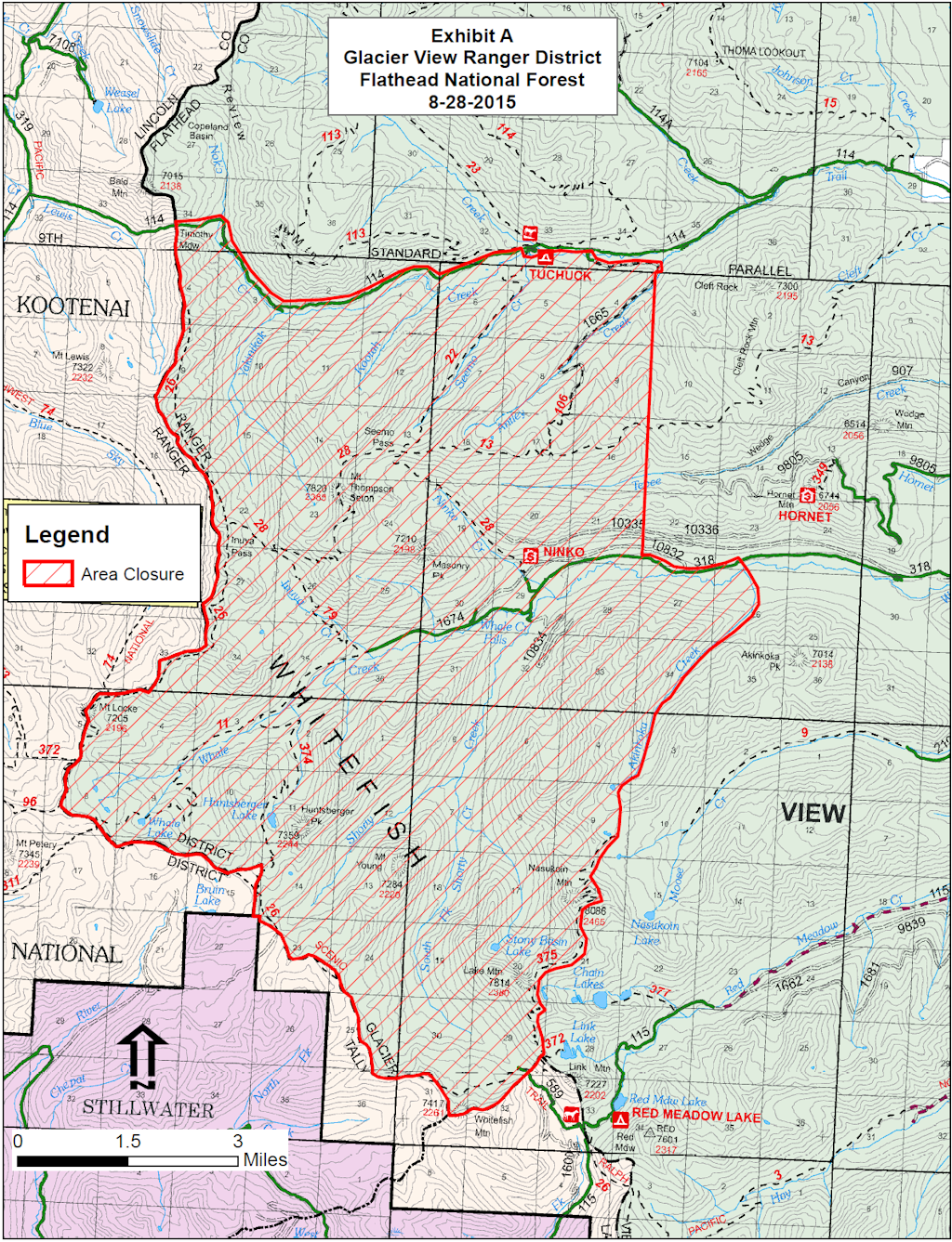
It’s official. The Forest Service is closing an area of the Flathead National Forest in the North Fork as a precautionary measure in case the Marston Blaze comes over the Whitefish Divide. This is not terribly likely, but the fire weather is a big concern over the next couple of days.

As near as I can tell from the map, only two roads are affected. Trail Creek Road is now closed just west of the Tuchuck Campground. Whale Creek Road is closed about four miles past the turnoff for the Hornet Lookout. At present, Red meadow Road is unaffected.

See the map below for details. For a bigger version, you can view/download the PDF (1.26 MB). You can also download the text of the official closure order.

Look for more information coming from the Northeast Kootenai Complex Fire information folks fairly soon.

Marston Fire - FNF Area Closure, Aug 28, 2015
Marston Fire – FNF Area Closure, Aug 28, 2015

Celebrating Glacier National Park’s North Fork – Aug 24

From our friends at the National Parks Conservation Association . . .

Greetings, friends!

We’re planning a summer celebration of Glacier National Park’s North Fork, right on the riverbank the morning of Aug. 24.

Sens. Jon Tester and Steve Daines together will welcome Canada’s Consulate General Marcy Grossman to commemorate a truly historic transboundary and bipartisan alliance, forever protecting the communities and culture of Waterton-Glacier International Peace Park.

Places such as Waterton-Glacier and the North Fork Flathead River Valley do not happen by accident. They are choices that we make together – choices such as the recent Canadian and US legislation that protects our North Fork heritage. Please join us to celebrate the priceless gift of many more summers on the river! We’ll bring the coffee.

Details and directions below…

Celebrating Glacier National Park’s North Fork

Directions to Blankenship Bridge (for non-North Forkers):

  • Enter Columbia Falls on US Hwy 2
  • Turn north on Nucleus Avenue
  • Turn Right at the “T” intersection, onto Railroad Street
  • Continue 8.5 miles up the North Fork Road
  • Turn Right on Blankenship Road
  • Continue 2.4 miles to Blankenship Bridge
  • Cross the bridge; parking is on the left

Grizzly and cubs relocated to North Fork

More wayward bears got dropped off in the North Fork. In this instance, near Frozen Lake . . .

A grizzly bear and her two cubs are being relocated after killing about 10 sheep near Lake Frances.

The Great Falls Tribune reports the bears will be moved Friday to a site in the North Fork of the Flathead River.

Grizzly bear management biologist, Mike Madel, says the bear family had been spotted near the east shore of Lake Frances, where they killed about 10 sheep.

Read more . . .

North Fork article appears in Flathead Living

A somewhat breathless article about the North Fork appears in the most recent edition of Flathead Living . . .

No matter the season, the trappings of civilization abate on the journey to Polebridge, the nagging fixtures of workaday refinement receding the further one travels north over this far-flung, off-the-grid landscape, its remote, rugged terrain stripping away the polished layers of urbanity like acetone.

Driving through the wild and scenic North Fork Flathead River corridor, the cell phone signal and chirping email notifications are the first to retreat, their attendant, tech-induced anxiety quieted and retooled with a streak of uncompromising individualism that runs deep through the valley and its scant population of year-round residents, who are handily outnumbered by the wildlife.

Read more . . .

No surprises in 2014 bull trout redd counts for Northwest Montana

The Region 1 bull trout redd counts are in . . .

Montana Fish, Wildlife & Parks (FWP) Fisheries Field crews have completed the annual inventory of bull trout spawning sites in the Clark Fork, Flathead, and Kootenai drainages, which comprise northwest Montana’s FWP Region One. Experienced observers walk known spawning areas and count the number of spawning nests called redds. Female bull trout excavate a depression in the streambed where she deposits her eggs which are immediately fertilized by a male. These nests, called redds, are typically four to six feet long by three feet wide, or even larger and are easily identified when walking down the stream channel. Redd counts are indicative of the abundance levels of spawning adult bull trout each year. Redd counts are used to assess status and trends in bull trout populations in northwest Montana.

According to Region One Fisheries Program Manager Mark Deleray, there are no surprises in the 2014 bull trout redd counts for the Clark Fork, Flathead, and Kootenai drainages in Northwestern Montana.

“In FWP Region One waters, bull trout redd numbers appear stable in all basins, being very similar to 10-year averages,” says Deleray. “In each basin, this year’s count may be slightly higher or lower than last year’s, but not significantly different than recent years.” Deleray adds that his staff and cooperators put in a significant amount of field time to collect these data every year. Avista and the Bonneville Power Administration provide funding assistance…

Read more . . .

Forest Service continues to fight several wildfires on the North Fork

The newspapers aren’t giving the North Fork’s “Hay Creek Complex” wildfires much attention, but there’s lots of radio traffic.

Here’s what seems to be going on…

The first clutch of fires, including the Akinkoka, Mathias and Hay Creek #1 and #2 blazes, are under control. The Tuchuck, Moose Creek and the Johnson Creek Fires have all been “controlled and contained.” However, yesterday’s storms have triggered several new fires that are generating a lot of chatter today. None of these new fires are very big — maybe a couple of acres worst case — but they are attracting aggressive suppression efforts:

  • Young Mountain #1 and #2 on the slopes above Shorty Creek, SSW of Young Mountain;
  • the Stony Fire, presumably near Stony Basin Lake, north of Lake Mountain;
  • the Link Lake #1 and #2 fires, probably NW of Link Mountain;
  • the Antley Creek Fire is a very small blaze near a ridge top SE of Antley Creek.

The Forest Service has a helibase operating from Moran Meadow, south of Polebridge. Please don’t stop or walk out there for a closer look. Those folks are kind of busy right now.

There are officially no trail closures.

Please read the morning fire report for more information and background. I will post the evening report as soon as it becomes available.

The Inciweb page for this set of fires is also updated regularly.

Lightening triggers four wildfires in the North Fork, a couple in Glacier Park

It seems the North Fork actually picked up four lightening-triggered wildfires during last Tuesday’s storms, with three still burning. The active fires are the Akinkoka Fire in the Moose Creek drainage and the Hay Creek No. 1 and Hay Creek No. 2 blazes near the west end of the Hay Creek drainage. The Forest Service seems to have turned most of its attention to the Hay Creek fires now after expending considerable resources on the Akinkoka Fire yesterday.

Glacier Park had two, only one of which — a small fire near Bowman Road — is still active, but nearly contained.

The Hungry Horse News has additional information . . .

The Flathead National Forest reports that a Type 3 management team has taken over responsibility for several wildfires that have been burning up the North Fork since a lightning storm passed through on July 29.

The fires are being collectively called the Hay Creek Complex and for now include fires from the Canada Border to the Coal Creek State Forest, between the Whitefish Divide and the North Fork Road.

Altogether, the Forest Service is using a Type 1 helicopter, two Type 2 helicopters and a Type 3 helicopter along with single engine air tankers to douse the fires.

Read more . . .

Akinkoka Fire getting plenty of attention

Forest Service crews and air support hit the Akinkoka Fire (the one up Moose Creek) pretty hard yesterday and have more assets scheduled today. Fire extent is on the order of 10-20 acres on steep, rugged terrain. The fire retardant dropped yesterday was still holding back the fire this morning. Ground crews and aircraft continue to work on the Akinkoka Fire as this message is posted.

No one seems as excited about the pair of small fires near the end of the Hay Creek drainage (the two are quite close together). There are people scheduled to be on that fire complex this morning.

Possible smoke was reported up the Red Meadow drainage late yesterday, but nothing was located by aircraft or ground personnel.

Area fire danger ‘high’; two fires on North Fork

Two lightening-caused fires kindled on the North Fork today, July 30. One up the Moose Creek drainage, the Akinkoka Fire, is being attacked aggressively. Another smaller, as yet unnamed, fire burning in heavy timber toward the upper reaches of the Hay Creek Drainage, should see action from fire crews tomorrow.

In general, fire danger is now considered high throughout the entire valley . . .

Local fire managers have moved the fire danger to “high” based on current and expected weather conditions.

The Montana Department of Natural Resources and Conservation announced the heightened fire danger Wednesday. No fire restrictions are in place at this time. Meanwhile, the U.S. Forest Service announced that dry lightning on Tuesday night caused four small fires on the Flathead National Forest. Two of the fires are along the North Fork of the Flathead River and another is north of Whitefish Lake.

Temperatures are forecasted to be in the 80s to 90s with the potential for lightning associated with afternoon thunderstorms. Hot, dry, and breezy conditions will continue to dry fine forest fuels such as grasses and brush that will then be more likely to catch fire.

Read more . . .