Tag Archives: road closures

Study: Closing roads counters effects of habitat loss for grizzlies

Grizzly bear cubs on old road bed - Montana Fish, Wildlife and Parks
Grizzly bear cubs on old road bed – Montana Fish, Wildlife and Parks

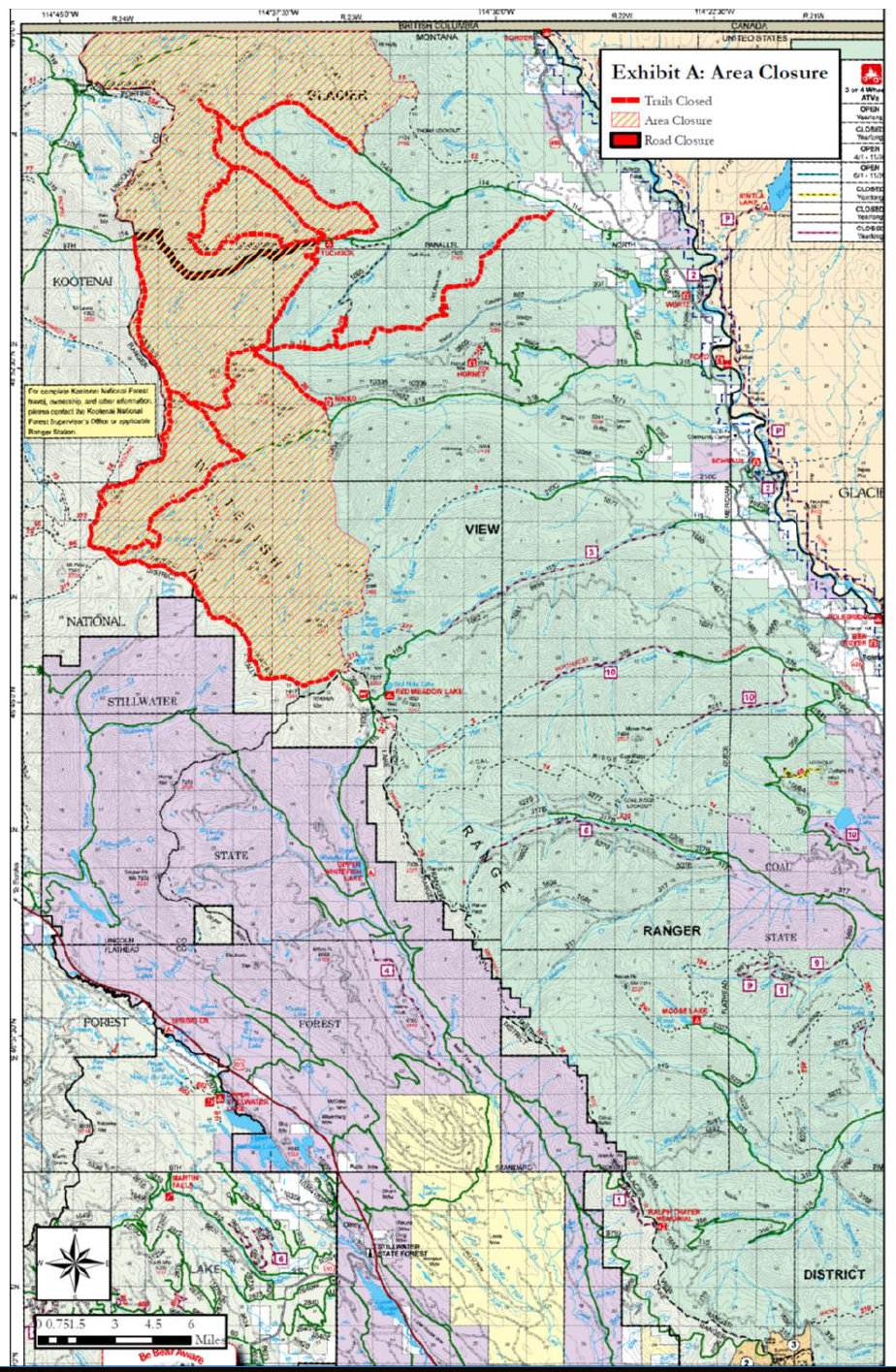
Here’s an interesting roads vs. grizzlies study based on DNA data out of British Columbia . . .

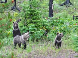
It’s simple math, says scientist Clayton Lamb. The closer grizzly bears are to humans, the more ways there are for the bears to die. Put more simply, more roads equal fewer grizzly bears.

In a recent study examining a long-term DNA dataset of grizzly bear activity in British Columbia, Lamb and his colleagues conclusively determined what scientists have long suspected: higher road density leads to lower grizzly bear density, a critical problem for a species still rebounding from a long period of human persecution.

“The problem with grizzly bears and roads is a North American-wide issue. This is the first time that strongly links roads to decreased grizzly bear density,” said Lamb…

Read more . . .

Gibraltar Ridge and Weasel Fire – Road, Trail & Area Closures

Gibraltar-Weasel Closure Map, Sep 10, 2017

This just in from the Flathead National Forest . . .

Media Contact: Janette Turk
(406) 758-5252
jturk@fs.fed.us

Kalispell, MT. September 10, 2017- The Gibralter Ridge Fire and the Weasel fire are burning in the Kootenai National Forest approximately 7 miles east of Eureka. The east side of the Gibraltar fire has moved into the mouth of the Blue Sky drainage in the Whitefish Range. The Weasel fire has moved near the Flathead and Kootenai forest boundary. To protect health and public safety by keeping the public out of the active fire area, the Kootenai National Forest has closed a large area from the Whitefish divide to the west boundary of the Fortine District, and from the Canadian Border to Deep Creek. The Flathead National Forest has closed an area north of Link lake trailhead north to the Canada border and east of the Kootenai border.

The following NFS Road is partially closed:

  • A portion of NFS Road #114 (Trail Creek Road) from the Flathead National Forest boundary to the junction with Stoken Bridge/Foothills Road. To support these efforts the Flathead National Forest has installed a gate on NFS Road #114 (Trail Creek) and has closed NFS Road #114 from mile point 8.8 to 14.8, the boundary with the Kootenai National Forest.

The following NFS trails are closed:

  • Trails 19, 23, 114, 113, 22, 13, 28, 79, 11, 13, 106 and 26 from the Link lake TH to the north.

The following NFS area is closed:

  • Area from the Link lake TH north along the Kootenai/Flathead NF boundary to the Canada border

Forest fire fighting resources are supporting the fires listed above and are prepared with initial attack resources as needed. For more information contact the Hungry Horse/Glacier View District at 406-387-3800.

Section of Glacier’s inside North Fork Road to open

Another stretch of the inside North Fork Road should open by the weekend. Don’t make any heavy bets on the rest of it opening up, though . . .

Roughly six miles of the North Fork Road between the Fish Creek Campground and Camas Creek Bridge is expected to open this weekend, Glacier National Park officials said on Wednesday.

Road crews are currently completing temporary repairs, including grading of the area and laying surface gravel to improve conditions after continuous flooding. The section of the road between Polebridge and Logging Creek opened to vehicle traffic in May.

The road between Camas Creek Bridge and Logging Creek will remain closed due to flooding and road washout.

Continue reading . . .

More roads open in Glacier Park

Glacier National Park is making steady progress opening roads this spring. The Inside North Fork Road is now open north of Logging Creek Ranger Station, making Bowman and Kintla Lakes accessible on the west side of the park. Also, another section of Going-to-the-Sun Road opened up, permitting public access as far as Avalanche on the west side and to Jackson Glacier Overlook on the east.

See the park’s road status page for details, as well as information on hiker/biker access.

Temporary road access closures in the North Fork area

From a press release posted to the Flathead National Forest web site . . .

Release Date: Jun 28, 2011

Public access on the Moose Creek Road, Forest Road #210C, and the Moran Creek Road, Forest Road #5241, both located north of Columbia Falls on the Flathead National Forest, will have temporary access changes beginning Friday, July 1.

The Moose Creek Road will be closed approximately 1mile before the Moose Creek Trailhead, Forest Trail #9, and the entire length of the Moran Creek Road will be closed.

The temporary closures are designed to mitigate disturbance to grizzly bears while activities of the Red Whale Fuels Reduction Project are taking place. The roads will open when the fuels reduction work is halted this fall. The temporary road closures will be implemented again next summer when the fuels reduction project continues.

For more information, please contact the Hungry Horse-Glacier View Ranger District at 387-3800.

Larry Wilson: Parts of North Fork Road now impassable

In this week’s column for the Hungry Horse News, Larry Wilson reports on the condition of the North Fork Road — essentially impassable near the border — and on the high points of the recent North Fork Landowners Association meeting . . .

Yes, there is still concern that there could be flooding on the North Fork. No, it is not a certainty, and we just have to wait and see how fast the snow melts in the high country.

For all intents and purposes, the North Fork Road is now closed from just north of Joe Franchini’s driveway to the international border. There are two obstacles…

Continue reading . . .

Red Meadow Road opening delayed

From the Hungry Horse News comes word that conditions are just too soggy for Red Meadow Road to open on schedule . . .

The Flathead National Forest will keep Red Meadow Road, Forest Road No. 114, about 40 miles north of Columbia Falls, closed to protect the road surface past the usual June 1 opening date. The gate on the road, about two miles off the North Fork Road, will be closed until road surface conditions improve.

Continue reading . . .

Winter road closures in effect at Glacier Park

It’s official. As of yesterday, most roads in Glacier Park are closed to motorized travel until the snow comes off in the spring. For North Forkers, this means that Camas Road is closed, so no cutting through the park for the next few months.

For more details, including information on road closures, winter entrance fees and procedures, and winter camping and backcountry access, see the press release.

Check the latest road conditions by visiting the park’s Road Status Page.

Appeals court: Flathead NF managed road work, grizzly habitat properly

From today’s online edition of the Missoulian . . .

Federal officials did a good job of balancing road work and grizzly bears in the Flathead National Forest, according to the 9th U.S. Circuit Court of Appeals.

“It’s a very significant victory for us,” Flathead forest planning staff officer Rob Carlin said Wednesday. “It supports us in the direction we’ve been taking at the Flathead.”

The court combined two cases involving road removal in areas burned in the 2003 wildfires. One was in the Roberts/Wedge fire along the North Fork of the Flathead River, and the other was along the west side of Hungry Horse Reservoir. Both areas have large grizzly bear populations and are covered by special forest plan rules for how many miles of road are allowed in grizzly habitat.

Read the entire article . . .

Ninko Creek Fire grows

Yesterday’s stiff winds blew up the Ninko Creek Fire to 500 acres from the previous 35. Here’s the latest information, as reported by the Flathead Beacon . . .

The Ninko Creek Fire located approximately 40 miles north of Columbia Falls in the Whale Creek Drainage on the Flathead National Forest had increased fire activity on Saturday, September 26. The fire increased to approximately 500 acres and is burning towards the 2003 Wedge Fire. The fire remains to the north of Forest Road #10355. Resources assigned to the incident include the Flathead Hot Shot Crew, several fire engines including two contract engines, and aerial resources. Forest Roads #318, #9805 and #907, Whale Creek, Ninko Creek and Wedge Canyon Roads, are closed at this time. Trail closures in the area are anticipated as well.

This one’s becoming a nuisance, folks.

If you want to keep an eye on things, see the InciWeb listing for the Ninko Fire.